
Lac de Vouglans
| Lac de Vouglans | |||||||
|---|---|---|---|---|---|---|---|
 |
|||||||
|
|||||||
|
|||||||
| Coordinates | 46 ° 29 '6 " N , 5 ° 40' 51" E | ||||||
| Data on the structure | |||||||
| Construction time: | 1964-1969 | ||||||
| Data on the reservoir | |||||||
| Altitude (at congestion destination ) | 429 m | ||||||
| Water surface | 11.04 km² | ||||||
| Reservoir length | 30 km | ||||||
| Storage space | 0.605 km³ | ||||||

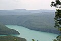
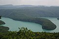
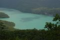
The Lac de Vouglans is a reservoir of the river Ain in the French region of Franche-Comte. It is located approx. 20 to 25 km southeast of Lons-le-Saunier . The area of the lake lies between the municipal areas of Pont-de-Poitte and Vouglans - Menouille .
With a storage volume of 605 million cubic meters, the 30 km long and up to 100 m deep Lac de Vouglans is the third largest reservoir in France after Lac de Serre-Ponçon and Lac de Sainte-Croix .
The lake was built from 1964 to 1969 by the power generation company EDF and is primarily used to generate electricity , but is also a popular recreational area. It is the top of six barrages in the Ain valley. The power plant, located directly below the dam, was put into operation in 1968. It has a maximum output of 285 MW, which is generated with three Francis turbines . With an additional pump group, water can be pumped from the Saut Mortier barrage below into the Lac de Vouglans.
Lac de Vouglans
Lac de Vouglans
Lac de Vouglans

Barrage du lac de Vouglans


Web links
- www.lac-de-vouglans.com (French, English, Dutch)
- Le Lac de Vouglans on eaufrance.fr (French)
- Zoom on the aménagements hydroélectriques de la vallée de l'Ain. EDF , April 2009, accessed on May 4, 2015 (French, description of the barrages in the Ain).