
Saint-Jean-de-Niost
| Saint-Jean-de-Niost | ||
|---|---|---|
.svg)
|
|
|
| region | Auvergne-Rhône-Alpes | |
| Department | Ain | |
| Arrondissement | Belley | |
| Canton | Lagnieu | |
| Community association | Plaine de l'Ain | |
| Coordinates | 45 ° 50 ' N , 5 ° 13' E | |
| height | 193-242 m | |
| surface | 14.19 km 2 | |
| Residents | 1,477 (January 1, 2017) | |
| Population density | 104 inhabitants / km 2 | |
| Post Code | 01800 | |
| INSEE code | 01361 | |
| Website | www.mairiesaintjeandeniost.fr | |
 Town hall ( Mairie ) of Saint-Jean-de-Niost |
||

Saint-Jean-de-Niost is a French commune with 1,477 inhabitants (as of January 1, 2017) in the Ain department of the Auvergne-Rhône-Alpes region . The municipality belongs to the arrondissement Belley and the canton Lagnieu . The inhabitants are called buyatins .
geography
Saint-Jean-de-Niost is located about 25 kilometers east-northeast of Lyon on the Ain River . Saint-Jean-de-Niost is surrounded by the neighboring communities of Charnoz-sur-Ain in the north, Blyes in the east, Saint-Vulbas in the east and south-east, Loyettes in the south, Saint-Maurice-de-Gourdans in the south and south-west and Béligneux in the West and northwest.
Part of the military complex Camp militiare de La Valbonne is located in the municipality.
Population development
| year | 1962 | 1968 | 1975 | 1982 | 1990 | 1999 | 2006 | 2017 |
| Residents | 265 | 248 | 369 | 490 | 810 | 1082 | 1375 | 1477 |
| Sources: Cassini and INSEE | ||||||||
Attractions
- Saint-Jean-Baptiste church from the 19th century
- Gourdans Castle from the 13th century
- Marcel Castle from the 16th century
- Bridge to Blyes
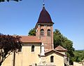
Saint-Jean-Baptiste church

Gourdans Castle

