Oncieu
| Oncieu | ||
|---|---|---|

|
|
|
| region | Auvergne-Rhône-Alpes | |
| Department | Ain | |
| Arrondissement | Belley | |
| Canton | Ambérieu-en-Bugey | |
| Community association | Plaine de l'Ain | |
| Coordinates | 45 ° 58 ′ N , 5 ° 28 ′ E | |
| height | 300-807 m | |
| surface | 7.76 km 2 | |
| Residents | 89 (January 1, 2017) | |
| Population density | 11 inhabitants / km 2 | |
| Post Code | 01230 | |
| INSEE code | 01279 | |
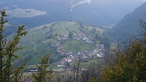
 View of Oncieu |
||
Oncieu is a French municipality with 89 inhabitants (at January 1, 2017) in the Ain department in the region of Auvergne Rhône-Alpes . It belongs to the canton of Ambérieu-en-Bugey in the Belley arrondissement .
geography
Oncieu is located at 463 m , about 35 kilometers south-east of the city of Bourg-en-Bresse and 30 kilometers west of Belley (as the crow flies) in the southern French Jura mountains. The area of the 7.76 km 2 municipal area includes part of the strongly reliefed western foothills of the Bugey landscape . The place lies on a rock cone at the bottom of the erosion valley of the Mandorne in the middle of a valley basin open to the south, which is flanked by steep slopes up to 500 m high. The municipal boundary follows the sharply drawn upper edge of this basin and forms a long tip in the north that follows the Mandorne up the valley. The brook drains the municipality and flows into the Albarine , which also represents the southern municipality boundary.
The development in the village is unusual in that the houses are arranged in a circle around an approximately 100 m wide open space. Outside the village there are two former water mills on the Mandorne, one for grain and one for paper.
Neighboring municipalities of Oncieu are Nivollet-Montgriffon and Aranc in the north, Évosges in the east, Argis in the south and Saint-Rambert-en-Bugey in the west.
history
Oncieu appears for the first time in 1191 under the Latinized name Onciacus in the documents as part of the lands of the powerful Benedictine Abbey of Saint-Rambert . Their territory, raised to margraviate in 1576 , came to France with the Treaty of Lyon in 1601.
Attractions
The view of the ring-shaped village from one of the many viewpoints along the edge of the Oncin basin is a sight to see. The village itself is classified as a site naturel . The rock Rocher de la Cathédrale , which has a rock gate visible from afar, stands uphill in a loop in the Mandorne Valley . There are caves at the edge of the Évosges plateau, such as the Grotte de Bruire and Grotte de l'Âne .
population
| Population development | |
|---|---|
| year | Residents |
| 1962 | 79 |
| 1968 | 63 |
| 1975 | 60 |
| 1982 | 63 |
| 1990 | 68 |
| 1999 | 78 |
| 2006 | 89 |
| 2011 | 93 |
With 89 inhabitants (as of January 1, 2017) Oncieu is one of the smallest communities in the Ain department. After the population had continuously decreased in the 20th century (189 people were counted in 1901), the trend was reversed in 1990 and the population increased again. The local residents of Oncieu are called Onciolan (e) s in French .
Economy and Infrastructure
The steep, south-facing slopes of the Oncieu basin were once used for viticulture and are still part of the Coteaux de l'Ain designation of geographical origin , but are no longer planted. In Oncieu there are only a few agricultural and service businesses, the rest of the working population are commuters who work in the larger towns in the area. Around half of the residential units are second homes.
Due to the unusual topography, the village has always been away from the larger thoroughfares. A small department road branches off from the D1504 and connects the village with the Cluse des Hôpitaux and the larger towns in the area. Its extension through the Mandorne Valley leads to Aranc. Another connection is with Évosges via a serpentine road. The next motorway ( A42 ) is around 22 kilometers away.
Web links
Individual evidence
- ↑ É. Philipon: Dictionnaire Topographique du Département de l'Ain . Imprimerie Nationale, 1911, p. 296 (French, online [PDF; accessed January 4, 2014]).
- ↑ Les sites classés en Rhône-Alpes. (PDF; 2.8 MB) In: DREAL Rhône-Alpes. Retrieved March 1, 2014 (French).
- ↑ French Statistics Institute ( www.insee.fr )
- ^ Oncieu - notice communal. In: cassini.ehess.fr. Retrieved on March 4, 2014 (French, INSEE population from 1968 ).

