Nivollet-Montgriffon
| Nivollet-Montgriffon | ||
|---|---|---|
|
|
||
| region | Auvergne-Rhône-Alpes | |
| Department | Ain | |
| Arrondissement | Belley | |
| Canton | Ambérieu-en-Bugey | |
| Community association | Plaine de l'Ain | |
| Coordinates | 46 ° 0 ' N , 5 ° 27' E | |
| height | 440-833 m | |
| surface | 8.24 km 2 | |
| Residents | 119 (January 1, 2017) | |
| Population density | 14 inhabitants / km 2 | |
| Post Code | 01230 | |
| INSEE code | 01277 | |
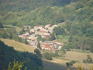
 The village of Nivollet seen from Mont Luisandre |
||
Nivollet-Montgriffon is a commune with 119 inhabitants (at January 1, 2017) in the department of Ain in the region Auvergne Rhône-Alpes . It belongs to the canton of Ambérieu-en-Bugey in the Belley arrondissement .
geography
Nivollet-Montgriffon is located at 744 m , about 30 kilometers south-east of the city of Bourg-en-Bresse (as the crow flies) in the southern French Jura mountains. The area of the 8.24 km 2 municipal area includes part of the strongly reliefed western foothills of the Bugey . The municipality consists of the two localities Nivollet and Montgriffon, which are a few kilometers apart. Montgriffon lies on a ridge that has been widened to form a plateau, which rises from the Cluse des Hôpitaux in the south to the Chaîne de l'Avocat in the north. Nivollet is located below this plateau on a small pass between the valleys of the Riez and Oiselon streams , which arise in the municipality and drain it to the west.
Neighboring municipalities of Nivollet-Montgriffon are Boyeux-Saint-Jérôme in the north, Corlier and Aranc in the east, and Oncieu and Saint-Rambert-en-Bugey in the south and L'Abergement-de-Varey in the west.
history
Nivoletum was first mentioned in 1213 as part of the possessions of the powerful Benedictine Abbey of Saint-Rambert . Montgriffon formed an independent small dominion, which was first under the abbey and later under the lords of Chatillon-de-Cornelle. The two villages had been under the sovereignty of the Counts of Savoy from the Middle Ages until they finally came to France through the Treaty of Lyon in 1601. The unified municipality, initially only called Montgriffon, was given the current name Nivollet-Montgriffon in 1883.
Attractions
The church of Montgriffon was built at the beginning of the 19th century in place of a previous medieval building, of which parts of the choir have been preserved. All that remains of the medieval Montgriffon Castle are foundations that are overgrown by the forest ( 45 ° 59 ′ 42.4 ″ N , 5 ° 28 ′ 32.1 ″ E ). It was once fortified by a moat, wall and drawbridge and was destroyed in Henry IV's war against the Counts of Savoy.
population
| Population development | |
|---|---|
| year | Residents |
| 1962 | 113 |
| 1968 | 103 |
| 1975 | 81 |
| 1982 | 63 |
| 1990 | 66 |
| 1999 | 87 |
| 2006 | 127 |
| 2011 | 135 |
With 119 inhabitants (as of January 1, 2017) Nivollet-Montgriffon is one of the smallest communities in the Ain department. After the population had steadily decreased in the 20th century (in 1901 there were still 349 people counted), the trend was reversed in 1990 and the population increased again.
Economy and Infrastructure
Nivollet-Montgriffon is a predominantly agricultural village, about half of the few people in work in the village belong to the primary sector. The village is located off the major thoroughfares on a departmental road that leads from Saint-Rambert-en-Bugey over the Col du Cendrier to Corlier . Another road reaches the municipality from L'Abergement-de-Varey across the valley of the Oiselon and connects Nivollet with Montgriffon. The next motorway ( A42 ) is around 20 kilometers away.
Web links
Individual evidence
- ↑ É. Philipon: Dictionnaire Topographique du Département de l'Ain . Imprimerie Nationale, 1911, p. 274, 293 (French, online [PDF; accessed January 4, 2014]).
- ↑ a b Nivollet-Montgriffon - notice communal. In: cassini.ehess.fr. Retrieved February 25, 2014 (French, INSEE population from 1968 ).
- ↑ French Statistics Institute ( www.insee.fr )


