Saint-Denis-en-Bugey
| Saint-Denis-en-Bugey | ||
|---|---|---|

|
|
|
| region | Auvergne-Rhône-Alpes | |
| Department | Ain | |
| Arrondissement | Belley | |
| Canton | Ambérieu-en-Bugey | |
| Community association | Plaine de l'Ain | |
| Coordinates | 45 ° 57 ′ N , 5 ° 20 ′ E | |
| height | 234–338 m | |
| surface | 2.61 km 2 | |
| Residents | 2,309 (January 1, 2017) | |
| Population density | 885 inhabitants / km 2 | |
| Post Code | 01500 | |
| INSEE code | 01345 | |
| Website | www.mairie-saintdenisenbugey.fr | |
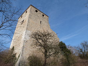
 Saint-Denis donjon from the 13th century |
||
Saint-Denis-en-Bugey is a French commune with 2,309 inhabitants (at January 1, 2017) in the department of Ain in the region Auvergne Rhône-Alpes . It belongs to the canton of Ambérieu-en-Bugey in the arrondissement of Belley and is a member of the Plaine de l'Ain community association .
geography
location
Saint-Denis-en-Bugey is located at 245 m , about 29 kilometers south-southeast of the prefecture of Bourg-en-Bresse , 35 kilometers northwest of the city of Belley and 44 kilometers east-northeast of the city of Lyon (as the crow flies). The village on the banks of the Albarine is part of the Bugey landscape . Neighboring communities of Saint-Denis-en-Bugey are Château-Gaillard and Ambérieu-en-Bugey in the north, Bettant in the east, Ambutrix in the south and Leyment in the southwest.
topography
The area of the 2.61 km 2 municipal area on the left bank of the Albarine includes the south side of its valley opening on the western edge of the Jura Mountains at the point where the river flows from the narrow cross valley Cluse des Hôpitaux into the wide plain of the Ain . The area is divided into three parts: a conical elevation at the end point of one of the Jura foothills, the flat settlement area around this elevation and - separated from it by the D1075 road - the fertile valley floor of the Albarine. The community reaches its highest point at 338 m on the approx. 100 m protruding elevation . The settlement area makes up about 46% of the municipal area and is densely built up compared to the rural surroundings. It merges seamlessly with that of Ambérieu-en-Bugey. 39% of the rest of the municipality is used for agriculture and consists of almost 15% forest, mainly in the area of the Jura foothills.
history
The settlement of the Saint-Denis area dates back to Roman times. Graves with coins from the time of Victorinus and Tetricus (3rd century) and a carved stone block that could have served as a taurobolium were found .
In the High Middle Ages , Saint-Denis was the center of a small lordship that was secured from the start with a castle on the hill above the village, from which the passage through the valleys of the Albarine and the Ain could be controlled at a strategically important point. The rule first belonged to the Lords of Coligny , passed to the House of La Tour-du-Pin from 1210 and came under the suzerainty of the Counts of Savoy in 1355 . With the Treaty of Lyon in 1601, all of Bugey became part of France. Document mentions of the place from this time are Castrum et vilia de S. Dionisio de Chauxzone (1337), Chauczon (1385) and Sainct Denys de Chousson (1563). In 1895 the parish changed its name from Saint-Denis-le-Chosson to Saint-Denis-en-Bugey . Until 1835, the now independent community of Bettans still belonged to Saint-Denis.
Attractions
The donjon from the 13th century, the Tour de Saint-Denis, has been preserved from the castle complex and is classified as a monument historique .
population
| Population development | |
|---|---|
| year | Residents |
| 1962 | 1170 |
| 1968 | 1200 |
| 1975 | 1220 |
| 1982 | 1511 |
| 1990 | 1780 |
| 1999 | 1944 |
| 2006 | 2053 |
| 2017 | 2309 |
With 2309 inhabitants (as of January 1, 2017), Saint-Denis-en-Bugey is one of the medium-sized communities in the Ain department. After the number of inhabitants had risen continuously in the 19th and first half of the 20th century (only 505 inhabitants were counted in 1841), the population increase accelerated considerably since around 1980. The local residents of Saint-Denis-en-Bugey are called Sandenien (ne) s in French .
Economy and Infrastructure
Until well into the 20th century, Saint-Denis-en-Bugey was a predominantly agricultural village. Today there are no longer any farms, instead a large part of the formerly arable land was built on with single-family houses. The development to a residential community, which had existed for a long time due to the direct proximity to the industrialized Ambérieu since the 19th century, accelerated, so that today most of the employed are commuters who do their work in the larger towns in the area. The few local businesses are part of the local small business.
The place is well developed in terms of traffic. It is located at the intersection of the department roads and the former national roads D1084 (Lyon – Geneva), D1075 (Bourg-en-Bresse – Grenoble) and D1504 (to Chambéry). Today these bypass the old town center. The next motorway connection to the A42 is around four kilometers away in Château-Gaillard. The Lyon – Genève railway runs through Saint-Denis-en-Bugey with the nearest station in Ambérieu, which is served by TER Rhône-Alpes trains. The airports in the region are Lyon-St-Exupéry (46 kilometers) and Chambéry-Savoie (78 kilometers).
education
In Saint-Denis-en-Bugey there is a state école primaire (elementary school with an integrated preschool ).
Web links
Individual evidence
- ↑ a b 2006 data from CORINE Land Cover , available e.g. B. at www.statistiques.developpement-durable.gouv.fr ( Memento of the original from March 24, 2016 in the Internet Archive ) Info: The archive link has been inserted automatically and has not yet been checked. Please check the original and archive link according to the instructions and then remove this notice. .
- ^ André Buisson: Carte Archéologique de la Gaule - Ain 01 . Académie des Inscriptions et Belles-Lettres , 1990, ISBN 2-87754-010-3 , pp. 33–34 (French, limited preview in Google Book search).
- ↑ a b É. Philipon: Dictionnaire Topographique du Département de l'Ain . Imprimerie Nationale, 1911, p. 374 (French, online [PDF; accessed January 4, 2014]).
- ↑ a b c Saint-Denis-en-Bugey - notice communale. In: cassini.ehess.fr. Retrieved July 8, 2015 (French, INSEE population from 1968 ).
- ↑ Tour de Saint-Denis in the Base Mérimée of the French Ministry of Culture (French)
- ↑ French Statistics Institute ( www.insee.fr )
- ^ Complete dossier on Saint-Denis-en-Bugey. In: INSEE . Retrieved July 8, 2015 (French).
