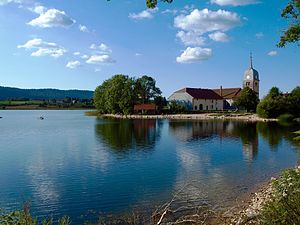
Lac de l'Abbaye
| Lac de l'Abbaye | ||
|---|---|---|

|
||
| The lake and the abbey of Grandvaux | ||
| Geographical location | Jura department , France | |
| Tributaries | two streams | |
| Drain | underground drain | |
| Places on the shore | Grande-Rivière | |
| Data | ||
| Coordinates | 46 ° 31 '48 " N , 5 ° 54' 45" E | |
|
|
||
| Altitude above sea level | 879 m | |
| surface | 90 ha | |
| length | 2.1 km | |
| width | 600 m | |
| Maximum depth | 19.5 m | |
The Lac de l'Abbaye is a lake in the French Jura , in the Jura department , 8 km west of Morez and about 40 km north-northwest of Geneva . It is located at 879 m on the parish of Grande-Rivière and covers an area of around 90 hectares. The Abbey of Grandvaux is located on a peninsula on the northeastern bank .
geography
The lake is 2.1 km long, a maximum of 600 m wide and extends in a south-west-north-east direction according to the general strike direction of the Jura chains in this section of the low mountain range. It lies on the edge of the wide valley of the Grandvaux in the High Jura. In the southeast, the Lac de l'Abbaye is flanked by the wooded ridge of the Forêt de la Joux Devant . The other parts of the bank are flat and partly have a swamp belt (moorland Les Touvières in the north). The greatest depth of the lake is 19.5 m. The Lac de l'Abbaye is fed by two short streams and probably several springs below the water surface. Due to the low inflow, the water has a relatively long mean retention time of an estimated two years. The Lac de l'Abbaye is drained underground. The water seeps away in the area below the hamlet of Sur le Moulin . Marking tests have shown that the water only comes to light again in the karst spring Source de l'Enragé at an air distance of 21 km in the south-south-west near Molinges in the valley of the Bienne . The sea circulation takes place according to the dimictic type. In many winters, the Lac de l'Abbaye freezes completely due to its high position in a basin (formation of a cold air lake ).
geology
In structural geological terms, the Lac de l'Abbaye lies in a synclinorium of the Jura folds . The Synclinorium of Grandvaux forms a wide hollow between the ridges of Forêt de la Joux Devant in the south-east and Forêt de la Joux Derrière in the north-west. The marly rock layers in the basin come from the Upper Cretaceous . During the high stages of the various ice ages , the basin was lined by the Jura glaciers with layers of marl and clay , which sealed off the otherwise permeable subsoil to such an extent that bogs and lakes could develop in the depressions.
Web links
- Information on Lac de l'Abbaye ( Memento of July 9, 2011 in the Internet Archive ) (French)
