Le Poizat-Lalleyriat
| Le Poizat-Lalleyriat | ||
|---|---|---|
|
|
||
| region | Auvergne-Rhône-Alpes | |
| Department | Ain | |
| Arrondissement | Nantua | |
| Canton | Nantua | |
| Community association | Haut-Bugey agglomeration | |
| Coordinates | 46 ° 9 ' N , 5 ° 42' E | |
| height | 497-1,241 m | |
| surface | 33.15 km 2 | |
| Residents | 720 (January 1, 2017) | |
| Population density | 22 inhabitants / km 2 | |
| Post Code | 01130 | |
| INSEE code | 01204 | |
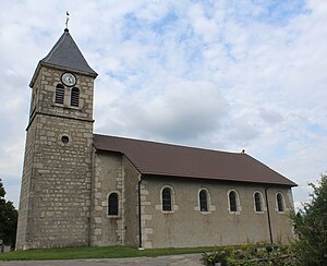
 Saint Blaise Church |
||
Le Poizat-Lalleyriat is a French municipality with 720 inhabitants (as of January 1 2017) in the department of Ain in the region Auvergne Rhône-Alpes . It belongs to the canton of Nantua in the same Arrondissement Nantua .
It was created as Commune nouvelle with effect from January 1, 2016 through the amalgamation of the previous municipalities Lalleyriat and Le Poizat , which have the status of a Commune déléguée in the new municipality . The administrative headquarters are in Lalleyriat.
structure
| District | former INSEE code |
Area (km²) | Population as of January 1, 2017 |
|---|---|---|---|
| Lalleyriat (administrative headquarters) | 01204 | 15.25 | 248 |
| Le Poizat | 01300 | 17.90 | 472 |
geography
The community is located around eight kilometers east of Nantua in the valley of the Combet river , a tributary of the Semine . The A40 motorway and the Bourg-en-Bresse – Bellegarde railway cross the municipality. There is a winter sports center in Le Poizat . Neighboring municipalities are Charix in the north, Saint-Germain-de-Joux in the northeast, Châtillon-en-Michaille in the east, Haut Valromey in the south and Les Neyrolles in the west.
Web links
Individual evidence
- ↑ Decree of the Prefecture on the creation of the Commune nouvelle Le Poizat-Lalleyriat of September 15, 2015 .
- ↑ current population according to INSEE
