Géovreisset
| Géovreisset | ||
|---|---|---|
|
|
||
| region | Auvergne-Rhône-Alpes | |
| Department | Ain | |
| Arrondissement | Nantua | |
| Canton | Nantua | |
| Community association | Haut-Bugey agglomeration | |
| Coordinates | 46 ° 15 ′ N , 5 ° 37 ′ E | |
| height | 567-754 m | |
| surface | 3.31 km 2 | |
| Residents | 874 (January 1, 2017) | |
| Population density | 264 inhabitants / km 2 | |
| Post Code | 01100 | |
| INSEE code | 01171 | |
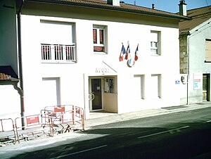
 Town Hall ( Mairie ) of Géovreisset |
||
Géovreisset is a French municipality with 874 inhabitants (at January 1, 2017) in the department of Ain in the region Auvergne Rhône-Alpes . It belongs to the canton of Nantua in the Arrondissement of Nantua .
geography
Géovreisset is located at 650 m , about three kilometers west of the city of Oyonnax and 30 kilometers east of the prefecture of Bourg-en-Bresse (beeline). The village extends in the north of the Haut- Bugey , in the Jura , in a hollow on the ridge to the west of the valley basin of Oyonnax.
The area of the 3.50 km² large municipality covers a section of the southern French Jura. The main part of the area is occupied by the ridge that separates the valley basin of Oyonnax in the east from that of the Oignin in the west. The narrow ridge of Châtelard , the valley basin of Géovreisset and the Bois de Samognat to the west , where the highest point in the community is reached at 754 m, are characteristic of the landscape . To the northeast, the community area extends to the outskirts of Oyonnax.
The hamlet of Pisse-Loup ( 630 m ) at the northern foot of the Châtelard is part of Géovreisset . Neighboring municipalities of Géovreisset are Oyonnax in the north, Bellignat in the east, Groissiat and Izernore in the south and Samognat in the west.
history
Géovreisset was first mentioned in a document in the 13th century. The sovereignty of the area passed to the Counts of Savoy in 1402 . With the Treaty of Lyon , the village came to France in 1601. Since the end of the 19th century, Géovreisset, together with the other communities in the valley of Oyonnax, experienced an economic boom through the introduction of the plastics industry (in particular the manufacture of balls, ping-pong balls and children's toys).
Attractions
The village church of Saint-Martin originally dates from the 11th and 12th centuries, but was remodeled and restored in the 17th century. The "Château" on a hill on the eastern outskirts is a mighty town house, which was built around 1850 by Félix Druard, who became famous as an industrialist and mayor of Oyonnax.
population
| year | 1962 | 1968 | 1975 | 1982 | 1990 | 1999 | 2006 | 2011 |
| Residents | 169 | 163 | 228 | 293 | 450 | 759 | 871 | 912 |
With 874 inhabitants (January 1, 2017), Géovreisset is one of the smaller communities in the Ain department. A marked increase in population has been recorded since the beginning of the 1970s. During this time the population has increased almost fivefold.
Economy and Infrastructure
For a long time, Géovreisset was a village dominated by agriculture and forestry. In addition, there are now some local small businesses. In the meantime, the village has also turned into a residential community. Many workers are commuters who work in the larger towns in the area, especially in Oyonnax. The new Haut-Bugey regional hospital is being built in the municipality of Géovreisset.
The village is away from the major thoroughfares, but is still well developed. The main access is from Oyonnax. Further road connections exist with Groissiat and Samognat. The closest connection to the A404 motorway (Saint-Martin-du-Frêne - Oyonnax) is around two kilometers away.
Web links
Individual evidence
- ↑ French Statistics Institute ( www.insee.fr )
- ↑ Géovreisset - notice communal. In: cassini.ehess.fr. Retrieved on June 14, 2015 (French, INSEE population from 1968 ).

