Peyriat
| Peyriat | ||
|---|---|---|
|
|
||
| region | Auvergne-Rhône-Alpes | |
| Department | Ain | |
| Arrondissement | Nantua | |
| Canton | Pont d'Ain | |
| Community association | Haut-Bugey agglomeration | |
| Coordinates | 46 ° 9 ' N , 5 ° 31' E | |
| height | 558-825 m | |
| surface | 5.96 km 2 | |
| Residents | 157 (January 1, 2017) | |
| Population density | 26 inhabitants / km 2 | |
| Post Code | 01430 | |
| INSEE code | 01293 | |
| Website | Peyriat | |
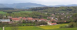
 View of Peyriat with the hamlet of Giriat in the background |
||
Peyriat is a French municipality with 157 inhabitants (at January 1, 2017) in the department of Ain in the region Auvergne Rhône-Alpes . It belongs to the canton of Pont-d'Ain in the Arrondissement of Nantua .
geography
Peyriat is located at 630 m , about 16 kilometers southwest of the city of Oyonnax and 23 kilometers east-southeast of the prefecture of Bourg-en-Bresse (beeline). The farming village extends in the north of Bugey , in a depression that opens north to the Izernore basin, in the Jura , east of the anticline of the Montagne de Berthiand.
The area of the municipal area of 5.96 km² covers a section of the southern French Jura. The central part is occupied by the Peyriat basin. However, the municipal area has no above-ground running water because the rainwater seeps away immediately into the porous calcareous subsoil. This hollow is flanked by several parallel ridges. In the west these are the Champ Dollan (with 815 m the highest elevation of Peyriat) and Les Bouchouses ( 811 m ), in the east the Crêt du Rasolat ( 730 m ).
The hamlet of Giriat ( 630 m ) belongs to Peyriat on a leveled area at the northern foot of the Crêt du Rasolat. Neighboring municipalities of Peyriat are Nurieux-Volognat in the north, Saint-Martin-du-Frêne and Maillat in the east, Ceignes in the south and Leyssard in the west.
history
Peyriat is mentioned for the first time in 1299 under the name Peyria . Over time, the spelling changed from Peria (1394) and Peyriacum (1483) to Peyriaz (1789). From the 12th century to 1402 Peyriat belonged to the rule of the Thoire-Villars, after which it came under the sovereignty of the Counts of Savoy . With the Treaty of Lyon , Peyriat came to France in 1601.
Attractions
The village church of Saint-Brice was built in the 14th century in Gothic style and redesigned in 1867.
population
| Population development | |
|---|---|
| year | Residents |
| 1962 | 97 |
| 1968 | 85 |
| 1975 | 87 |
| 1982 | 120 |
| 1990 | 154 |
| 1999 | 158 |
| 2006 | 165 |
| 2011 | 172 |
With 157 inhabitants (as of January 1, 2017), Peyriat is one of the small communities in the Ain department. After the population had decreased in the first half of the 20th century (174 people were still counted in 1891), a significant increase in population has been recorded since the beginning of the 1970s. The local residents of Peyriat are called Peyriatis in French .
Economy and Infrastructure
Until well into the 20th century, Peyriat was predominantly a village characterized by agriculture , in particular dairy and cattle breeding, as well as forestry. In addition, there are now some local small businesses. In the meantime, the village has also turned into a residential community. Many workers are commuters who work in the larger towns in the area.
The village is located away from the larger thoroughfares. It can be reached from three sides, namely from Nurieux in the north, Maillat in the east (on the A40 motorway) and from Ceignes in the south. The closest connection to the A40 motorway is around five kilometers away.
Web links
Individual evidence
- ↑ French Statistics Institute ( www.insee.fr )
- ^ Peyriat - notice communale. In: cassini.ehess.fr. Retrieved on June 14, 2015 (French, INSEE population from 1968 ).
