Charix
| Charix | ||
|---|---|---|
|
|
||
| region | Auvergne-Rhône-Alpes | |
| Department | Ain | |
| Arrondissement | Nantua | |
| Canton | Nantua | |
| Community association | Haut-Bugey agglomeration | |
| Coordinates | 46 ° 11 ′ N , 5 ° 41 ′ E | |
| height | 580-1,046 m | |
| surface | 18.27 km 2 | |
| Residents | 285 (January 1, 2017) | |
| Population density | 16 inhabitants / km 2 | |
| Post Code | 01130 | |
| INSEE code | 01087 | |
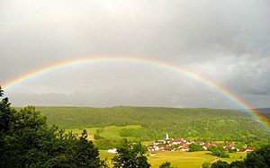
 General view of Charix |
||
Charix is a French municipality with 285 inhabitants (at January 1, 2017) in the department of Ain in the region Auvergne Rhône-Alpes . It belongs to the canton of Nantua in the Arrondissement of Nantua .
geography
Charix is located at 780 m , about nine kilometers south of the city of Oyonnax and 35 kilometers east of the prefecture of Bourg-en-Bresse (as the crow flies). The farming village extends in the Haut- Bugey , in the Jura , on a promontory surrounded by the source stream of the Lac de Sylans at the eastern foot of Mont Burdet , north of the deeply cut Cluse de Nantua .
The area of the municipal area of 18.27 km² covers a section of the southern French Jura. The southern boundary runs in the area of the Cluse de Nantua with the Lac de Sylans. It forms a transverse valley that stretches from Nantua to the Valserine catchment area through the chains of the Upper Jura.
From this breakthrough valley the community area extends northward into the Mulde ( Combe ) of Charix, which forms a syncline in the Jura . It rises further towards the north, gradually narrows and ends with the basin of Lac Genin , which is surrounded by a moorland. The Charix valley basin is flanked on both sides by forest heights, in the east by the Bois de Puthod ( 986 m ) and in the west by the ridge of Mont Burdet , on which the highest point of Charix is reached at 1043 m .
In addition to the actual place, Charix also includes various hamlets and farm groups, namely:
- Moulin de Charix ( 595 m ) in the Cluse de Nantua northeast of the Lac de Sylans
- Les Combes ( 765 m ) on the southeast slope of Mont Burdet
- Charix-le-Haut ( 800 m ) in the Charix basin
Neighboring municipalities of Charix are Oyonnax in the north, Échallon , Plagne and Saint-Germain-de-Joux in the east, Le Poizat-Lalleyriat and Les Neyrolles in the south and Nantua and Apremont in the west.
history
Charix is first mentioned in the 12th century as the property of the Nantua monastery. In the 13th century, the village passed to the rule of the Thoire-Villars and came with this 1402 under the suzerainty of the Counts of Savoy . With the Treaty of Lyon , Charix came to France in 1601.
Attractions
The village church of Saint-Amant von Charix was rebuilt in the 19th century on the site of a previous medieval building. Natural attractions include the Lac Genin and its surroundings. The Grotte de la Serra is the longest measured cave in the Ain department. In the Cluse de Nantua is the A40 motorway with the Viaduc de Charix, which spans the Charix Valley in an arch at a height of more than 60 m, and the Viaduc de Sylans, a 1.2 km long Lehnen viaduct along the slope north of Lac de Sylans.
population
| Population development | |
|---|---|
| year | Residents |
| 1962 | 253 |
| 1968 | 230 |
| 1975 | 205 |
| 1982 | 254 |
| 1990 | 261 |
| 1999 | 265 |
| 2006 | 289 |
| 2011 | 289 |
With 285 inhabitants (as of January 1, 2017) Charix is one of the small communities in the Ain department. After the population had decreased significantly in the first half of the 20th century (469 people were counted in 1891), a slight increase in population has been recorded since the mid-1970s. The local residents of Charix are called Charian (e) s in French .
Economy and Infrastructure
Until well into the 20th century, Charix was predominantly a village characterized by agriculture , in particular cattle and dairy farming, as well as forestry. In addition, there are now some local small businesses. Coral limestone is mined in a quarry. Many workers are commuters who work in the larger towns in the area.
The village is located away from the larger thoroughfares. The main access is from Moulin-de-Charix on the departmental road D1084, which leads from Bellegarde-sur-Valserine to Nantua. Further road connections exist with Apremont, Oyonnax and Échallon. The closest connection to the A40 motorway , which crosses the municipality, is around six kilometers away.
There is a state elementary school ( école élémentaire ) in Charix .
Web links
Individual evidence
- ↑ É. Philipon: Dictionnaire Topographique du Département de l'Ain . Imprimerie Nationale, 1911, p. 95 (French, online [PDF; accessed January 2, 2014]).
- ↑ French Statistics Institute ( www.insee.fr )
- ^ Charix - notice communal. In: cassini.ehess.fr. Retrieved on June 14, 2015 (French, INSEE population from 1968 ).


