Samognat
| Samognat | ||
|---|---|---|
|
|
||
| region | Auvergne-Rhône-Alpes | |
| Department | Ain | |
| Arrondissement | Nantua | |
| Canton | Pont d'Ain | |
| Community association | Haut-Bugey agglomeration | |
| Coordinates | 46 ° 15 ′ N , 5 ° 35 ′ E | |
| height | 288-731 m | |
| surface | 14.01 km 2 | |
| Residents | 653 (January 1, 2017) | |
| Population density | 47 inhabitants / km 2 | |
| Post Code | 01580 | |
| INSEE code | 01392 | |
| Website | samognat.fr | |
 Mairie Samognat |
||
Samognat is a French municipality with 653 inhabitants (at January 1, 2017) in the department of Ain in the region Auvergne Rhône-Alpes . It belongs to the canton of Pont-d'Ain and the Arrondissement of Nantua .
geography
Samognat is located at 437 m , about six kilometers west of the city of Oyonnax and 27 kilometers east-northeast of the prefecture of Bourg-en-Bresse (as the crow flies). The farming village extends in the north of Bugey , on a promontory east of the Oignin in the Jura , in a basin in which the Oignin is dammed by the Moux dam.
The area of the 14.01 km² municipal area covers a section of the southern French Jura. The south-western part of the area is occupied by the approximately 2 km wide basin of Samognat, which forms a syncline in the Folded Jura . The elongated reservoir of Moux is located in this basin. To the east, the community area extends over a densely wooded slope to the ridge ( Bois de Samognat ), which separates the Juralang valleys from Oignin and Ange (Oyonnax).
Below Samognat, the Oignin overcomes a height step with several waterfalls and then flows into a deeply cut valley up to its confluence with the Ain . The municipality floor extends northward in a narrow strip and includes the steep eastern valley flank of the Oignin and the Ain respectively. At 731 m , the highest point in Samognat is reached on the ridge of the Bois de Diesse . In the far north, Samognat has a share in Lac de Coiselet , a reservoir of the Ain.
In addition to the actual place, Samognat also includes various hamlets and farm groups, including (from south to north):
- Condamine de la Belloire ( 420 m ) on the southern edge of the Samognat basin
- Les Combelles ( 470 m ) to the east adjoining the village
- Arfontaine ( 560 m ) on a ledge on the eastern slope of the Oignin
- Royère ( 370 m ) on the eastern slope of the Oignin
Neighboring places of Samognat are Coisia (municipality Thoirette-Coisia ) and Dortan in the north, Oyonnax and Géovreisset in the east, Izernore in the south and Matafelon-Granges in the west.
history
Samognat is first mentioned in a document in 1158 under the name Samonia . Over time, the spelling changed from Samonies (1250), Samogniacus (1351) and Samogniaz (1500) to Samogna (1650). Since the 11th century Samognat belonged to the lords of Thoire-Villars and in 1402 came under the sovereignty of the Counts of Savoy . With the Treaty of Lyon , the village came to France in 1601.
Attractions
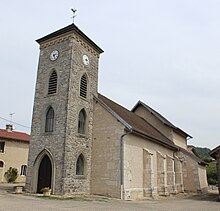
The village church of Saint-Barthélemy in Samognat was originally built in the Gothic style, but later changed several times.
population
| Population development | |
|---|---|
| year | Residents |
| 1962 | 110 |
| 1968 | 119 |
| 1975 | 156 |
| 1982 | 238 |
| 1990 | 285 |
| 1999 | 422 |
| 2006 | 627 |
| 2011 | 704 |
With 653 inhabitants (as of January 1, 2017) Samognat is one of the small communities in the Ain department. After the population had decreased in the first half of the 20th century (310 people were still counted in 1891), a significant increase in population has been recorded again since the beginning of the 1960s. Since then, the population has increased almost sixfold. Local residents of Samognat hot in French Samognatis .
Economy and Infrastructure
Until the 20th century, Samognat was mainly a village characterized by agriculture , especially dairy farming and cattle breeding, as well as forestry. In the first half of the 20th century, various businesses that were dependent on water power were set up on the Oignin, including mills, a turnery, a comb and button factory. Today there are only a few local small businesses and the hydropower plants on Oignin and Ain. In the meantime the village has turned into a residential community. Many workers are commuters who work in the larger towns in the area.
The village is located off the major thoroughfares on a departmental road that leads from Oyonnax to Thoirette . Other road connections exist with Izernore, Chancia and Coisia. The closest connection to the A404 motorway (Saint-Martin-du-Frêne - Oyonnax) is around eight kilometers away.
Web links
Individual evidence
- ↑ É. Philipon: Dictionnaire Topographique du Département de l'Ain . Imprimerie Nationale, 1911, p. 402 (French, online [PDF; accessed January 4, 2014]).
- ↑ French Statistics Institute ( www.insee.fr )
- ↑ Samognat - notice communale. In: cassini.ehess.fr. Retrieved on June 19, 2015 (French, INSEE population from 1968 ).

