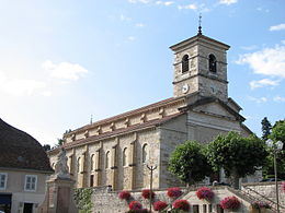
Les Avenières
| Les Avenières | ||
|---|---|---|
|
|
||
| local community | Les Avenières Veyrins-Thuellin | |
| region | Auvergne-Rhône-Alpes | |
| Department | Isère | |
| Arrondissement | La Tour-du-Pin | |
| Coordinates | 45 ° 38 ' N , 5 ° 34' E | |
| Post Code | 38630 | |
| Former INSEE code | 38022 | |
| Incorporation | January 1, 2016 | |
| status | Commune déléguée | |
 View of Les Avenières from Walibipark |
||
Les Avenières is a former French commune with 5,619 inhabitants (as of January 1 2017) in the department of Isère in the region Auvergne Rhône-Alpes . It was part of the La Tour-du-Pin arrondissement , in the canton of Morestel . The inhabitants are called Avenièrants .
With effect from January 1, 2016, it was merged with the former municipality of Veyrins-Thuellin and merged to form Commune nouvelle Les Avenières Veyrins-Thuellin .
geography
Les Avenières is located about 60 kilometers east-southeast of Lyon on the Rhone on a hill. The area is crossed by the Bièvre river. Les Avenières is surrounded by the neighboring towns of Le Bouchage in the north, Saint-Benoît (Département Ain) in the northeast, Brégnier-Cordon in the east, Aoste and Granieu in the south, Corbelin in the southwest and Veyrins-Thuellin in the west.
The former community consisted of the districts of Ciers , Buvin and Curtille .
history
There was a bridge here early on. In 1989, during construction work, wooden piles from between 40 BC and 120 AD were found.
Population development
| 1962 | 1968 | 1975 | 1982 | 1990 | 1999 | 2006 | 2011 | |
|---|---|---|---|---|---|---|---|---|
| 3117 | 3181 | 3402 | 3495 | 3933 | 4308 | 4806 | 5437 | |
| Sources: Cassini and INSEE | ||||||||
Attractions
- Ciers church from the 19th century
- Château Bertaudières
- Château Cerisier
- Château Eau-Morte

