Veyrins-Thuellin
| Veyrins-Thuellin | ||
|---|---|---|
|
|
||
| local community | Les Avenières Veyrins-Thuellin | |
| region | Auvergne-Rhône-Alpes | |
| Department | Isère | |
| Arrondissement | La Tour-du-Pin | |
| Coordinates | 45 ° 38 ' N , 5 ° 32' E | |
| Post Code | 38630 | |
| Former INSEE code | 38541 | |
| Incorporation | January 1, 2016 | |
| status | Commune déléguée | |
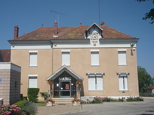
 Former town hall of Veyrins-Thuellin |
||
Veyrins-Thuellin is a former French commune with 2,120 inhabitants (as of January 1 2017) in the department of Isère in the region Auvergne Rhône-Alpes . It was part of the La Tour-du-Pin arrondissement , in the canton of Morestel . The inhabitants are called Verlinois .
It was merged with the former municipality of Les Avenières with effect from January 1, 2016 and merged to form Commune nouvelle Les Avenières Veyrins-Thuellin .
geography
Veyrins-Thuellin is located about 30 kilometers west-northwest of Chambéry . Veyrins-Thuellin is surrounded by the neighboring towns of Le Bouchage in the north, Les Avenières in the east, Corbelin in the south, Dolomieu in the west and Vézeronce-Curtin in the north-west.
The development of traffic takes place through the former Route nationale 75 (today's D1075).
Population development
| 1962 | 1968 | 1975 | 1982 | 1990 | 1999 | 2006 | 2012 | |
|---|---|---|---|---|---|---|---|---|
| 979 | 932 | 1,261 | 1,315 | 1,328 | 1,482 | 1,722 | 1,899 | |
| Sources: Cassini and INSEE | ||||||||
Attractions
- Saint-Jean-l'Évangéliste church in Veyrins
- Saint-Jean-l'Évangéliste church in Thuellin
- Thuellin Castle

