
Epierre
| Epierre | ||
|---|---|---|
|
||
| region | Auvergne-Rhône-Alpes | |
| Department | Savoie | |
| Arrondissement | Saint-Jean-de-Maurienne | |
| Canton | Saint-Pierre-d'Albigny | |
| Community association | Porte de Maurienne | |
| Coordinates | 45 ° 27 ' N , 6 ° 18' E | |
| height | 348-2,746 m | |
| surface | 19.36 km 2 | |
| Residents | 759 (January 1, 2017) | |
| Population density | 39 inhabitants / km 2 | |
| Post Code | 73220 | |
| INSEE code | 73109 | |
 Mairie Épierre |
||

Épierre is a commune in the French department of Savoie in the region of Auvergne Rhône-Alpes . It belongs to the canton of Saint-Pierre-d'Albigny and the Arrondissement of Saint-Jean-de-Maurienne .
Geography, infrastructure
The village is served by the SNCF with the Culoz – Modane railway line and the shared station with Saint-Léger . It borders on Argentine to the north, La Léchère to the east, Montgellafrey to the south-east, La Chapelle to the south-west, Saint-Léger to the east and Saint-Pierre-de-Belleville to the north-east .
Population development
| year | 1962 | 1968 | 1975 | 1982 | 1990 | 1999 | 2008 | 2014 |
|---|---|---|---|---|---|---|---|---|
| Residents | 750 | 753 | 761 | 820 | 650 | 578 | 673 | 776 |
Attractions
- Castle ruins
- Military cemetery

Castle ruins
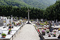
Military cemetery

Épierre – Saint-Léger train station

Disused train station

Ascension Church


economy
Thermphos International has a production facility in Épierre .
Web links
Commons : Épierre - Collection of images, videos and audio files