
Tournemire (Cantal)
|
Tournemire Tornamira |
||
|---|---|---|

|
|
|
| region | Auvergne-Rhône-Alpes | |
| Department | Cantal | |
| Arrondissement | Aurillac | |
| Canton | Naucelles | |
| Community association | Pays de Salers | |
| Coordinates | 45 ° 3 ' N , 2 ° 29' E | |
| height | 708-1,046 m | |
| surface | 9.68 km 2 | |
| Residents | 126 (January 1, 2017) | |
| Population density | 13 inhabitants / km 2 | |
| Post Code | 15310 | |
| INSEE code | 15238 | |
| Website | http://www.webvilles.fr/villes/15238-tournemire.php | |

Tournemire ( Occitan : Tornamira ) is a French municipality with 126 inhabitants (as of January 1 2017) in the Cantal in the region of Auvergne Rhône-Alpes ; it belongs to the arrondissement of Aurillac and the canton of Naucelles .
Tournemire is one of the most beautiful villages in France . Its architecture is under monument protection ( Monument historique ). The municipality is located in the Volcans d'Auvergne Regional Nature Park .
Population development
| year | 1962 | 1968 | 1975 | 1982 | 1990 | 1999 | 2006 | 2013 |
| Residents | 272 | 299 | 214 | 183 | 163 | 145 | 142 | 129 |
| Source: Cassini and INSEE | ||||||||
Attractions
- Anjony Castle
- Tournemire castle ruins
- church
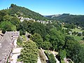
Tournemire as seen from the castle

Anjony Castle

Townscape


Personalities
- Jean Du Vair, father of Guillaume du Vair (1556–1621) was born in Tournemire
- Johannes de Tornamira (around 1329–1395), professor of medicine at the University of Montpellier
Web links
Commons : Tournemire - collection of images, videos and audio files