
Saint-Simon (Cantal)
|
Saint-Simon Sant Simon |
||
|---|---|---|
|
||
| region | Auvergne-Rhône-Alpes | |
| Department | Cantal | |
| Arrondissement | Aurillac | |
| Canton | Vic-sur-Cère | |
| Community association | Bassin d'Aurillac | |
| Coordinates | 44 ° 58 ′ N , 2 ° 29 ′ E | |
| height | 655–1,031 m | |
| surface | 27.27 km 2 | |
| Residents | 1,140 (January 1, 2017) | |
| Population density | 42 inhabitants / km 2 | |
| Post Code | 15130 | |
| INSEE code | 15215 | |
| Website | Saint-Simon | |

Saint-Simon ( Occitan : Sant Simon ) is a French city and a municipality with 1140 inhabitants (as of January 1 2017) in the Cantal in the region of Auvergne Rhône-Alpes . The municipality belongs to the arrondissement Aurillac and the canton Vic-sur-Cère (until 2015: canton Aurillac-4 ). The inhabitants are called Saint-Simonions .
location
Saint-Simon belongs to the historical region of Carladès and is located about five kilometers northeast of the city center of Aurillac on the Jordanne River . Saint-Simon is surrounded by the neighboring municipality of Marmanhac in the north, Velzic in the north-east, Polminhac in the east, Giou-de-Mamou in the south and south-east, Aurillac in the south and south-west, Naucelles in the south-west, Reilhac in the west and Jussac in the north-west.
Population development
| year | 1962 | 1968 | 1975 | 1982 | 1990 | 1999 | 2006 | 2013 |
| Residents | 846 | 842 | 1.007 | 959 | 989 | 1,018 | 1,071 | 1,143 |
| Source: Cassini and INSEE | ||||||||
Attractions
- Saint-Sigismond church
- La Force Castle
- Oyez Castle from the 12th century with a manor house from the 16th century, Monument historique
- Lalaubie Castle from the 18th century, Monument historique
- The 17th century castle and domain of Le Martinet
- Labeau Castle
- Commander
- The three menhirs of Saint Simon stand near the D58
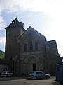
Church in Saint-Sigismond

Oyez Castle

Lalaubie Castle

Labeau Castle


