
Mandailles-Saint-Julien
|
Mandailles-Saint-Julien Mandalha e Sant Julian |
||
|---|---|---|
|
||
| region | Auvergne-Rhône-Alpes | |
| Department | Cantal | |
| Arrondissement | Aurillac | |
| Canton | Vic-sur-Cère | |
| Community association | Bassin d'Aurillac | |
| Coordinates | 45 ° 4 ′ N , 2 ° 39 ′ E | |
| height | 837-1,780 m | |
| surface | 35.37 km 2 | |
| Residents | 187 (January 1, 2017) | |
| Population density | 5 inhabitants / km 2 | |
| Post Code | 15590 | |
| INSEE code | 15113 | |
| Website | Mandailles-Saint-Julien | |
 Town hall (Mairie) of Mandailles-Saint-Julien |
||

Mandailles-Saint-Julien ( Occitan : Mandalha e Sant Julian ) is a French city and a municipality with 187 inhabitants (as of January 1 2017) in the Cantal in the region of Auvergne Rhône-Alpes . The municipality belongs to the arrondissement Aurillac and the canton Vic-sur-Cère (until 2015: canton Aurillac-4 ). The inhabitants are called Mandalhaires or Saint-Julienois .
location
Mandailles-Saint-Julien belongs to the historic region of Carladès and is located about 18 kilometers northeast of Aurillac on the Jordanne River . Mandailles-Saint-Julien is surrounded by the neighboring municipality of Le Falgoux and Le Claux in the north, Lavigerie in the northeast, Laveissière in the east and northeast, Saint-Jacques-des-Blats in the east and southeast, Thiézac in the south, Saint-Cirgues-de- Jordanne in the southwest and Saint-Projet-de-Salers in the west.
Population development
| year | 1962 | 1968 | 1975 | 1982 | 1990 | 1999 | 2006 | 2013 |
| Residents | 351 | 284 | 450 | 363 | 276 | 226 | 203 | 199 |
| Source: Cassini and INSEE | ||||||||
Attractions
- Church in Saint-Julien-de-Jordanne
- Church in Mandailles
- Liadouze waterfall
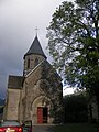
Church in Saint-Julien-de-Jordanne
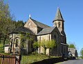
Church in Mandailles

Liadouze waterfall


