
Saint-Cernin (Cantal)
|
Saint-Cernin Sant Sarnin |
||
|---|---|---|

|
|
|
| region | Auvergne-Rhône-Alpes | |
| Department | Cantal | |
| Arrondissement | Aurillac | |
| Canton | Naucelles | |
| Community association | Pays de Salers | |
| Coordinates | 45 ° 4 ′ N , 2 ° 25 ′ E | |
| height | 556-985 m | |
| surface | 46.75 km 2 | |
| Residents | 1,072 (January 1, 2017) | |
| Population density | 23 inhabitants / km 2 | |
| Post Code | 15310 | |
| INSEE code | 15175 | |
| Website | http://www.saint-cernin.fr/ | |
 Center of Saint-Cernin |
||

Saint-Cernin ( Occitan : Sant Sarnin ) is a French municipality with 1,072 inhabitants (as of January 1 2017) in the Cantal in the region of Auvergne Rhône-Alpes ; it belongs to the arrondissement of Aurillac and the canton of Naucelles .
geography
Saint-Cernin is about 14 kilometers north-northwest of Aurillac . Saint-Cernin is surrounded by the neighboring communities of Saint-Cirques-de-Malbert in the north and north-west, Saint-Chamant in the north and north-east, Saint-Projet-de-Salers in the north-east, Tournemire in the east, Marmanhac in the east and south-east, Jussac in the South, Freix-Anglards in the south and southwest and Saint-Illide in the west.
The former route nationale 122 (today's D922) runs through the municipality .
Population development
| year | 1962 | 1968 | 1975 | 1982 | 1990 | 1999 | 2006 | 2013 |
| Residents | 1,677 | 1,448 | 1.314 | 1,245 | 1,164 | 1,128 | 1,068 | 1,118 |
| Source: Cassini and INSEE | ||||||||
Attractions
- Romanesque church
- Bournazel Castle with a mill
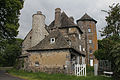
- Le Cambon Castle, Monument historique
- Ourzeaux Castle
- Ragheaud Castle from the 15th century, monument historique since 1964
- Donjon of Marzes

The church around 1910.

Le Cambon Castle
Ragheaud Castle

Donjon of Marzes

_ch%C3%A2teau_Cambon.jpg)


Personalities
- Henri Mondor (1885–1962), doctor and literary historian