
Laroquebrou
|
Laroquebrou Laròcabrau |
||
|---|---|---|

|
|
|
| region | Auvergne-Rhône-Alpes | |
| Department | Cantal | |
| Arrondissement | Aurillac | |
| Canton | Saint-Paul-des-Landes | |
| Community association | Châtaigneraie Cantalienne | |
| Coordinates | 44 ° 58 ′ N , 2 ° 12 ′ E | |
| height | 429-693 m | |
| surface | 17.15 km 2 | |
| Residents | 880 (January 1, 2017) | |
| Population density | 51 inhabitants / km 2 | |
| Post Code | 15150 | |
| INSEE code | 15094 | |
| Website | http://www.laroquebrou.fr/ | |
 Town Hall (Mairie) of Laroquebrou |
||

Laroquebrou ( Occitan : Laròcabrau ) is a French municipality with 880 inhabitants (as of January 1 2017) in the department of Cantal in the region of Auvergne Rhône-Alpes . The municipality belongs to the arrondissement of Aurillac and the canton of Saint-Paul-des-Landes (until 2015: canton Laroquebrou ). The inhabitants are called Roquais .
geography
Laroquebrou is about twenty kilometers west-northwest of Aurillac . Laroquebrou is surrounded by the neighboring communities of Saint-Santin-Cantalès in the north and north-east, Nieudan in the east, Saint-Étienne-Cantalès in the south-east, Saint-Gérons in the south, Siran in the west and south-west and Montvert in the west and north-west.
Population development
| year | 1962 | 1968 | 1975 | 1982 | 1990 | 1999 | 2006 | 2013 |
| Residents | 1,237 | 1,193 | 1.014 | 1,023 | 1,048 | 1,080 | 1,001 | 831 |
| Source: Cassini and INSEE | ||||||||
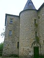
Attractions
- Saint-Martin Church, Monument historique
- Laroque Castle
- Messac Castle, Monument historique

Saint Martin Church

Laroque Castle
Messac Castle

.jpg)

Personalities
- Jacques Faizant (1918-2006), illustrator
- René Cance (1895–1982), politician (PCF), Mayor of Le Havre (1956–1959 and 1965–1971)
Web links
Commons : Laroquebrou - collection of images, videos and audio files