
Marmanhac
| Marmanhac | ||
|---|---|---|

|
|
|
| region | Auvergne-Rhône-Alpes | |
| Department | Cantal | |
| Arrondissement | Aurillac | |
| Canton | Naucelles | |
| Community association | Bassin d'Aurillac | |
| Coordinates | 45 ° 0 ′ N , 2 ° 29 ′ E | |
| height | 627-971 m | |
| surface | 24.24 km 2 | |
| Residents | 730 (January 1, 2017) | |
| Population density | 30 inhabitants / km 2 | |
| Post Code | 15250 | |
| INSEE code | 15118 | |

Marmanhac is a French city and a municipality with 730 inhabitants (as of January 1 2017) in the Cantal in the region of Auvergne Rhône-Alpes . The municipality belongs to the arrondissement of Aurillac and the canton of Naucelles (until 2015: canton Aurillac-4 ). The inhabitants are called Marmanhacois .
location
Marmanhac belongs to the historic region of Carladès and is located about nine kilometers north-northeast of the city center of Aurillac on the Authre . Marmanhac is surrounded by the neighboring municipality of Saint-Cernin in the north and north-west, Girgols in the north, Laroquevieille in the north-east, Velzic in the east, Saint-Simon in the south and Jussac in the west.
Population development
| year | 1962 | 1968 | 1975 | 1982 | 1990 | 1999 | 2006 | 2013 |
| Residents | 841 | 863 | 890 | 789 | 749 | 706 | 723 | 703 |
| Source: Cassini and INSEE | ||||||||
Attractions
- Saint-Saturnin Church, Monument historique
- L'Estang Castle, Monument historique
- Sédaiges Castle, Monument historique
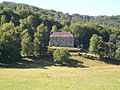
- La Voulte Castle, Monument historique

Church in Saint-Saturnin
Estang Castle

Sédaiges Castle

La Voulte Castle


