
Reilhac (Cantal)
|
Reilhac Relhac |
||
|---|---|---|
|
||
| region | Auvergne-Rhône-Alpes | |
| Department | Cantal | |
| Arrondissement | Aurillac | |
| Canton | Naucelles | |
| Community association | Bassin d'Aurillac | |
| Coordinates | 44 ° 58 ′ N , 2 ° 25 ′ E | |
| height | 582-867 m | |
| surface | 8.89 km 2 | |
| Residents | 1,105 (January 1, 2017) | |
| Population density | 124 inhabitants / km 2 | |
| Post Code | 15250 | |
| INSEE code | 15160 | |
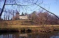
 View of Reilhac |
||

Reilhac ( Occitan : Relhac ) is a municipality in the French region of Auvergne-Rhône-Alpes and has 1,105 inhabitants (as of January 1, 2017). The municipality belongs to the Cantal department , the Aurillac arrondissement and is part of the Naucelles canton (until 2015: Jussac canton ).
location
Reilhac is located in the Massif Central . The Authre crosses the community. Reilhac is surrounded by the neighboring communities of Jussac in the north, Saint-Simon in the east, Naucelles in the south and south-east and Crandelles in the west and south-west.
Population development
| 1962 | 1968 | 1975 | 1982 | 1990 | 1999 | 2008 | 2013 | |
|---|---|---|---|---|---|---|---|---|
| 463 | 538 | 814 | 768 | 901 | 957 | 1,013 | 1,096 | |
| Source: Cassini and INSEE | ||||||||
Attractions
- Saint-Laurent church from the 12th century, alterations from the 14th century, monument historique since 1968
- Rectory
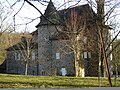
- Broussette Castle from the 15th century with a chapel from 1335 and a mill on the Authre, Monument historique
- Messac Castle with a tower from the 13th century

Saint Laurent Church
Broussette Castle
Messac Castle


Web links
Commons : Reilhac - collection of images, videos and audio files