Lavigerie
| Lavigerie | ||
|---|---|---|
|
|
||
| region | Auvergne-Rhône-Alpes | |
| Department | Cantal | |
| Arrondissement | Saint-Flour | |
| Canton | Murat | |
| Community association | Hautes Terres | |
| Coordinates | 45 ° 8 ′ N , 2 ° 45 ′ E | |
| height | 1,054-1,773 m | |
| surface | 24.25 km 2 | |
| Residents | 107 (January 1, 2017) | |
| Population density | 4 inhabitants / km 2 | |
| Post Code | 15300 | |
| INSEE code | 15102 | |
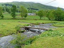
 View of Lavigerie |
||
Lavigerie is a French municipality with 107 inhabitants (at January 1, 2017) in the Cantal in the region of Auvergne Rhône-Alpes ; it belongs to the arrondissement of Saint-Flour .
geography
Lavigerie is a mountain village in the Monts du Cantal on the western foothills of the Massif Central . The Santoire River has its source in the municipality's territory.
Population development
| year | 1962 | 1968 | 1975 | 1982 | 1990 | 1999 | 2007 | 2016 |
| Residents | 248 | 231 | 181 | 147 | 121 | 102 | 102 | 105 |
| Sources: Cassini and INSEE | ||||||||
Web links
Commons : Lavigerie - collection of images, videos and audio files

