Brezons
| Brezons | ||
|---|---|---|
|
|
||
| region | Auvergne-Rhône-Alpes | |
| Department | Cantal | |
| Arrondissement | Saint-Flour | |
| Canton | Saint-Flour-2 | |
| Community association | Saint-Flour Community | |
| Coordinates | 44 ° 58 ′ N , 2 ° 48 ′ E | |
| height | 785-1,813 m | |
| surface | 43.20 km 2 | |
| Residents | 183 (January 1, 2017) | |
| Population density | 4 inhabitants / km 2 | |
| Post Code | 15230 | |
| INSEE code | 15026 | |
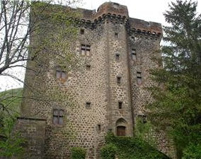
 Tower of the Château de la Boyle |
||
Brezons is a commune with 183 inhabitants (at January 1, 2017) in the Cantal in the region of Auvergne Rhône-Alpes . It belongs to the arrondissement of Saint-Flour and the canton of Saint-Flour-2 .
geography
The community is located south of the Monts du Cantal mountain range , around 30 kilometers northeast of Aurillac . Neighboring communities are:
- Albepierre-Bredons in the north,
- Paulhac in the northeast,
- Cézens in the east,
- Pierrefort in the southeast,
- Saint-Martin-sous-Vigouroux in the southwest,
- Malbo to the west as well
- Pailherols and Saint-Jacques-des-Blats to the north-west.
The municipality is part of the Volcans d'Auvergne Regional Nature Park . The Plomb du Cantal, the highest mountain peak of the massif, lies on the northern municipal boundary. The Brezons river , which has the same name as the municipality, rises here , and crosses the municipality in a north-south direction, passes the municipality's capital and drains on to Truyère .
Transport links
The community is supplied by the D39 département road, which eventually changes to the neighboring valley to the east and overcomes the mountain range there via the Col du Prat de Bouc pass .
Population development
| year | 1968 | 1975 | 1982 | 1990 | 1999 | 2006 | 2016 |
| Residents | 451 | 350 | 310 | 252 | 208 | 215 | 188 |
Attractions
- Church Saint-Hilaire from the 12th century monument historique
- Château de la Boyle , fortified castle from the 15th century, monument historique
Web links
Individual evidence
- ↑ Entry no. PA00093477 in the Base Mérimée of the French Ministry of Culture (French)
- ↑ Entry no. PA00093476 in the Base Mérimée of the French Ministry of Culture (French)
