
Bonnac (Cantal)
| Bonnac | ||
|---|---|---|
|
||
| region | Auvergne-Rhône-Alpes | |
| Department | Cantal | |
| Arrondissement | Saint-Flour | |
| Canton | Saint-Flour-1 | |
| Community association | Hautes Terres | |
| Coordinates | 45 ° 13 ' N , 3 ° 10' E | |
| height | 560-1,007 m | |
| surface | 22.6 km 2 | |
| Residents | 164 (January 1, 2017) | |
| Population density | 7 inhabitants / km 2 | |
| Post Code | 15500 | |
| INSEE code | 15022 | |
 View of Bonnac |
||

Bonnac ( Occitan identical) is a French municipality with 164 inhabitants (at January 1, 2017) in the department of Cantal in the region of Auvergne Rhône-Alpes (before 2016 Auvergne ). It belongs to the canton of Saint-Flour-1 (until 2015 Massiac ) and the arrondissement of Saint-Flour . The inhabitants are called Bonnacois .
location
Bonnac is about 56 kilometers east-northeast of Aurillac . Neighboring municipalities are Molompize in the north, Massiac in the east and northeast, Saint-Poncy in the southeast, Saint-Mary-le-Plain in the south, Ferrières-Saint-Mary in the southwest, Peyrusse in the west and Charmensac in the west and northwest.
Population development
| year | 1962 | 1968 | 1975 | 1982 | 1990 | 1999 | 2006 | 2011 | 2016 |
|---|---|---|---|---|---|---|---|---|---|
| Residents | 314 | 277 | 234 | 175 | 170 | 158 | 151 | 168 | 165 |
| Source: Cassini and INSEE | |||||||||
Attractions
- Saint-Barthélemy Church, Monument historique
- Priory
- Grand Cross of the Knights Templar
- Bonnac Castle
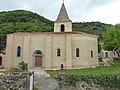
Saint Barthélemy Church

Priory

Grand Cross

Bonnac Castle


Web links
Commons : Bonnac - collection of images, videos and audio files