
Roffiac
| Roffiac | ||
|---|---|---|
|
||
| region | Auvergne-Rhône-Alpes | |
| Department | Cantal | |
| Arrondissement | Saint-Flour | |
| Canton | Saint-Flour-1 | |
| Community association | Saint-Flour Community | |
| Coordinates | 45 ° 3 ' N , 3 ° 2' E | |
| height | 815-1,006 m | |
| surface | 21.26 km 2 | |
| Residents | 615 (January 1, 2017) | |
| Population density | 29 inhabitants / km 2 | |
| Post Code | 15100 | |
| INSEE code | 15164 | |

The French community Roffiac lies in the region of Auvergne Rhône-Alpes in the Cantal in the Arrondissement Saint-Flour and in the District of Saint-Flour-1 .
The rural community on 21.26 square kilometers is located on a basalt plateau at 815 to 1006 meters above sea level and has 615 inhabitants (as of January 1, 2017). The D 926 runs through the town to the northwest of Saint-Flour.
Attractions
- Romanesque ( basalt ) church of Saint-Gal, former castle chapel from the 12th century, sacristy and stair tower from the 15th century, modern bell tower with 4 bell openings, only two of which are occupied
- Round, 25 meter high medieval stair tower of the former castle
- "Métier à ferrer", four-pillar, outdoor hoof shoeing device (19th century)
- Dolmen of the Crousette , Véderat

The Romanesque church of Roffiac

Romanesque church - jewelry on the abside
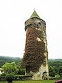
Remnants of the Roffiac castle


Web links
Commons : Roffiac - collection of images, videos and audio files