Coltines
|
Coltines Coltina |
||
|---|---|---|
|
|
||
| region | Auvergne-Rhône-Alpes | |
| Department | Cantal | |
| Arrondissement | Saint-Flour | |
| Canton | Saint-Flour-1 | |
| Community association | Saint-Flour Community | |
| Coordinates | 45 ° 6 ′ N , 2 ° 59 ′ E | |
| height | 913–1,010 m | |
| surface | 19.02 km 2 | |
| Residents | 454 (January 1, 2017) | |
| Population density | 24 inhabitants / km 2 | |
| Post Code | 15170 | |
| INSEE code | 15053 | |
| Website | Coltines | |
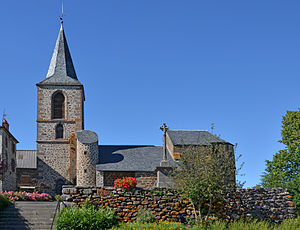
 Church Saint-Martial and Saint-Vincent |
||
Coltines ( Occitan : Coltina ) is a central French city and a municipality with 454 inhabitants (at January 1, 2017) in the Cantal in the region of Auvergne Rhône-Alpes .
location
The place Coltines is at an altitude of approx. 960 m above sea level. d. M. at the creek Le Babory . The distance to Saint-Flour is only 14 km (driving distance) in a south-easterly direction.
Population development
| year | 1800 | 1851 | 1901 | 1954 | 1999 | 2013 |
| Residents | 780 | 728 | 602 | 406 | 404 | 452 |
The population decline in the 20th century is mainly due to the lack of jobs as a result of the mechanization of agriculture . Due to its proximity to the city of Saint-Flour, there has been a slight increase again in recent decades.
economy
The place Coltines used for centuries to exclusively agriculturally oriented and in the main self-sustaining villages ( hameaux ) and individual farms in the area as a small craft, trade and service center. Since the middle of the 20th century tourism has played a not insignificant role for the economic life of the place in the form of the rental of holiday apartments ( gîtes ).
history
Two large stone graves ( dolmen ) testify to the presence of humans in the Neolithic Age . On the subsequent history of Coltines little is known - the church was formerly of eight hamlets ( hamlets ), of which there are five: Vaux , Bardon , Toul , Chassagne and Frayssinette . During the Huguenot War (1562–1598) the medieval castle ( château ) was razed; a new building was destroyed during the French Revolution .
Attractions
- The existence of the parish church of Saint-Martial et Saint-Vincent is first attested in the early 12th century; the nave is from this time . The apse is broken polygonally and significantly raised compared to the nave , which indicates a construction period in the late Gothic period . The bell tower ( clocher ) replaced a dilapidated bell gable in the 19th century . The building has been recognized as a monument historique since 1937 .
- The Musée de l'Agriculture Auvergnate deals with the agricultural traditions of the Auvergne.
- outside
- The dolmen of Touls , consisting only of an open chamber with capstone, stands about one and a half kilometers north of the town ( 45 ° 6 ′ 23 ″ N , 2 ° 59 ′ 12 ″ E ) and has been recognized as a monument historique since 1986 .
- The almost identical Dolmen du Bardon is located about two kilometers east on the border with the neighboring municipality of Talizat ( 45 ° 5 ′ 43 ″ N , 3 ° 1 ′ 0 ″ E ). It was also classified as a Monument historique in 1937 .
Web links
- Coltines, history - photos + info (French)
- Coltines, church - photos + information (French)
- Coltines, Museum - Photos + Info (French)
- Coltines, Dolmen de Touls - Photos + information (French)
- Coltines, Dolmen de Toul - Photos and information (English)
- Coltines, Dolmen du Bardon - photo + short information (French)
- Coltines, Dolmen du Bardon - Photo + tooltips (English)
Individual evidence
- ↑ Église Saint-Vincent, Coltines in the Base Mérimée of the French Ministry of Culture (French)
- ^ Dolmen de Touls, Coltines in the Base Mérimée of the French Ministry of Culture (French)
- ↑ Dolmen du Bardon, Coltines in the Base Mérimée of the French Ministry of Culture (French)
