
Chaudes-Aigues
|
Chaudes-Aigues Chaldasaigas |
||
|---|---|---|
.svg)
|
|
|
| region | Auvergne-Rhône-Alpes | |
| Department | Cantal | |
| Arrondissement | Saint-Flour | |
| Canton | Neuvéglise | |
| Community association | Saint-Flour Community | |
| Coordinates | 44 ° 58 ′ N , 3 ° 0 ′ E | |
| height | 740-1,004 m | |
| surface | 53.16 km 2 | |
| Residents | 886 (January 1, 2017) | |
| Population density | 17 inhabitants / km 2 | |
| Post Code | 15100 | |
| INSEE code | 15045 | |
 View of Chaudes-Aigues |
||

Chaudes-Aigues ( Occitan : Chaldasaigas ) is a central French city and a municipality with 886 inhabitants (as of January 1 2017) in the Cantal in the region of Auvergne Rhône-Alpes . The municipality belongs to the arrondissement of Saint-Flour and the canton of Neuvéglise (until 2015: canton of Chaudes-Aigues ). The inhabitants are called Chaudesaiguois or Caldaguès .
location
Chaudes-Aigues is located about 20 kilometers south-southwest of Saint-Flour on the Truyère , which borders the municipality in the north. Chaudes-Aigues is surrounded by the neighboring communities of Neuvéglise-sur-Truyère in the north, Saint-Martial in the north-east, Maurines in the east, Anterrieux in the east and south-east, Deux-Verges in the south-east, Jabrun in the south and south-west and Espinasse in the west.
Population development
| year | 1962 | 1966 | 1975 | 1982 | 1990 | 1999 | 2006 | 2013 |
| Residents | 1,218 | 1,114 | 1,187 | 1,186 | 1.110 | 986 | 972 | 913 |
| Source: Cassini and INSEE | ||||||||
economy
The place is best known for its thermal springs , which are also used for district heating.
Attractions
- Saint-Martin-et-Saint-Blaise church from the 12th century
- Penitent animal chapel
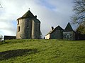
- Couffour Castle, originally from the 12th century, rebuilt into the 16th century, monument historique since 1969
- Montvallat Castle
- Geothermal Museum

Saint-Blaise-et-Saint-Martin church

Penitent animal chapel (Notre-Dame-de-Pitié)
Couffour Castle

Montvallat Castle

_IMG_2708.jpg)

_P1040607.jpg)