
Ferrières-Saint-Mary
|
Ferrières-Saint-Mary Farreiras e Sant Mari |
||
|---|---|---|
|
||
| region | Auvergne-Rhône-Alpes | |
| Department | Cantal | |
| Arrondissement | Saint-Flour | |
| Canton | Saint-Flour-1 | |
| Community association | Hautes Terres | |
| Coordinates | 45 ° 11 ′ N , 3 ° 4 ′ E | |
| height | 633-1,178 m | |
| surface | 19.17 km 2 | |
| Residents | 245 (January 1, 2017) | |
| Population density | 13 inhabitants / km 2 | |
| Post Code | 15170 | |
| INSEE code | 15069 | |
| Website | http://ferrieres-st-mary.com/ | |
 View of Ferrières-Saint-Mary |
||

Ferrières-Saint-Mary ( Occitan Farreiras e Sant Mari ) is a French municipality with 245 inhabitants (at January 1, 2017) in the department of Cantal in the region of Auvergne Rhône-Alpes (before 2016 Auvergne ). It belongs to the canton of Saint-Flour-1 (until 2015 Massiac ) and the arrondissement of Saint-Flour . The inhabitants are called Ferrièrois .
location
Ferrières-Saint-Mary is located about 55 kilometers east-northeast of Aurillac . Neighboring municipalities are Peyrusse in the north and northwest, Bonnac in the north and northeast, Saint-Mary-le-Plain in the east, Rézentières in the south and southeast, Talizat and Valjouze in the south and southwest and Joursac in the west and southwest.
The national route 122 runs through the municipality .
Population development
| year | 1962 | 1968 | 1975 | 1982 | 1990 | 1999 | 2006 | 2011 | 2016 |
|---|---|---|---|---|---|---|---|---|---|
| Residents | 564 | 519 | 476 | 436 | 402 | 299 | 255 | 253 | 244 |
| Source: Cassini and INSEE | |||||||||
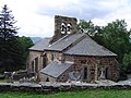
Attractions
- Church in Ferrières
- Saint-Mary-de-Clos church from the 19th century, monument historique since 1992

Church in Ferrières-Saint-Mary
Saint-Mary-le-Cros church

