
Les Ternes
|
Les Ternes Las Tèrnas |
||
|---|---|---|
|
||
| region | Auvergne-Rhône-Alpes | |
| Department | Cantal | |
| Arrondissement | Saint-Flour | |
| Canton | Saint-Flour-2 | |
| Community association | Saint-Flour Community | |
| Coordinates | 45 ° 0 ′ N , 3 ° 1 ′ E | |
| height | 896–1,061 m | |
| surface | 19.13 km 2 | |
| Residents | 584 (January 1, 2017) | |
| Population density | 31 inhabitants / km 2 | |
| Post Code | 15100 | |
| INSEE code | 15235 | |

Les Ternes ( Occitan Las TERNAS ) is a French municipality with 584 inhabitants (at January 1, 2017) in the Cantal in the region of Auvergne Rhône-Alpes (before 2016 Auvergne ). The municipality belongs to the arrondissement Saint-Flour and the canton Saint-Flour-2 (until 2015 Saint-Flour-Sud ).
location
Les Ternes is located about 44 kilometers east-northeast of Aurillac on the Alleuze river , which is also called Jurol in this section . Les Ternes is surrounded by the neighboring communities of Tanavelle in the north, Villedieu in the east and north-east, Neuvéglise-sur-Truyère in the south, Cussac in the west and south-west and Paulhac in the west and north-west.
Population development
| year | 1962 | 1968 | 1975 | 1982 | 1990 | 1999 | 2006 | 2011 | 2016 |
| Residents | 509 | 459 | 428 | 425 | 450 | 455 | 522 | 592 | 588 |
| Source: Cassini and INSEE | |||||||||
Attractions
- Alleuzet dolmen , a historic monument since 1986
- Saint-Martin church from the 15th century, monument historique since 1926
- Les Ternes castle from the 14th century, demolished a short time later, then rebuilt in the 16th century, monument historique since 2008
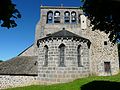
Saint Martin Church

Les Ternes castle

.jpg)
Personalities
- Roger le Fort (1285 / 1288–1367), Bishop of Orléans (1321–1328) and Limoges (1328–1343), Archbishop of Bourges (1343–1367)
Web links
Commons : Les Ternes - collection of images, videos and audio files