Tanavelle
|
Tanavelle Tanavela |
||
|---|---|---|
|
|
||
| region | Auvergne-Rhône-Alpes | |
| Department | Cantal | |
| Arrondissement | Saint-Flour | |
| Canton | Saint-Flour-2 | |
| Community association | Saint-Flour Community | |
| Coordinates | ||
| height | 943-1,089 m | |
| surface | 13.58 km 2 | |
| Residents | 234 (January 1, 2017) | |
| Population density | 17 inhabitants / km 2 | |
| Post Code | 15100 | |
| INSEE code | 15232 | |
| Website | http://www.tanavelle.fr/ | |
 Town hall (Mairie) of Tanavelle |
||
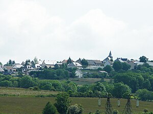
Tanavelle ( Occitan Tanavela ) is a French municipality with 234 inhabitants (at January 1, 2017) in the department of Cantal in the region of Auvergne Rhône-Alpes (before 2016 Auvergne ). It belongs to the canton of Saint-Flour-2 (until 2015 Saint-Flour-Sud ) and the Arrondissement of Saint-Flour . The inhabitants are called Tanavellois .
location
Tanavelle is about 55 kilometers east-northeast of Aurillac . Neighboring communities are Roffiac in the north and east, Villedieu in the south-east, Les Ternes in the south, Paulhac in the west and south-west and Valuéjols in the north-west.
Population development
| year | 1962 | 1968 | 1975 | 1982 | 1990 | 1999 | 2006 | 2011 | 2016 |
|---|---|---|---|---|---|---|---|---|---|
| Residents | 270 | 259 | 240 | 213 | 219 | 250 | 251 | 242 | 238 |
| Source: Cassini and INSEE | |||||||||
Attractions
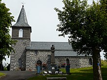
- Sainte-Foy church from the 12th / 13th centuries Century, Monument historique since 1984
Web links
Commons : Tanavelle - collection of images, videos and audio files

