
Chaliers
|
Chaliers Chalalher |
||
|---|---|---|
|
||
| region | Auvergne-Rhône-Alpes | |
| Department | Cantal | |
| Arrondissement | Saint-Flour | |
| Canton | Neuvéglise | |
| Community association | Saint-Flour Community | |
| Coordinates | 44 ° 57 ' N , 3 ° 14' E | |
| height | 728-1,002 m | |
| surface | 18.37 km 2 | |
| Residents | 160 (January 1, 2017) | |
| Population density | 9 inhabitants / km 2 | |
| Post Code | 15320 | |
| INSEE code | 15034 | |

Chaliers ( Occitan : Chalalher ) is a central French city and a municipality with 160 inhabitants (as of January 1, 2017) in the Cantal in the region of Auvergne Rhône-Alpes (before 2016: Auvergne ). The municipality belongs to the arrondissement of Saint-Flour and the canton of Neuvéglise (until 2015: canton of Ruynes-en-Margeride ).
location
Chaliers is about 13 kilometers southeast of Saint-Flour on the Truyère . Chaliers is surrounded by the neighboring communities of Ruynes-en-Margeride in the north and north-west, Clavières in the east and north-east, Lorcières in the east, Chaulhac in the south and south-east and Val d'Arcomie in the west and south-west.
Population development
| year | 1962 | 1966 | 1975 | 1982 | 1990 | 1999 | 2006 | 2013 |
| Residents | 268 | 236 | 218 | 214 | 227 | 196 | 176 | 180 |
| Source: Cassini and INSEE | ||||||||
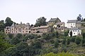
Attractions
- Saint-Martin church, historic monument since 1992
- Longevialle Castle
- Roudil house from 1777

Place with church

Longevialle Castle
House Roudil
.jpg)


Web links
Commons : Chaliers - collection of images, videos and audio files