
Saint-Martin-sous-Vigouroux
|
Saint-Martin-sous-Vigouroux Sant Martí de Vigorós |
||
|---|---|---|

|
|
|
| region | Auvergne-Rhône-Alpes | |
| Department | Cantal | |
| Arrondissement | Saint-Flour | |
| Canton | Saint-Flour-2 | |
| Community association | Saint-Flour Community | |
| Coordinates | 44 ° 55 ' N , 2 ° 48' E | |
| height | 670-1,371 m | |
| surface | 19.29 km 2 | |
| Residents | 236 (January 1, 2017) | |
| Population density | 12 inhabitants / km 2 | |
| Post Code | 15230 | |
| INSEE code | 15201 | |

Saint-Martin-sous-Vigouroux ( Occitan Sant Martí de Vigorós ) is a French municipality with 236 inhabitants (at January 1, 2017) in the department of Cantal in the region of Auvergne Rhône-Alpes (before 2016 Auvergne ). It belongs to the canton of Saint-Flour-2 (until 2015 Saint-Flour-Sud ) and the Arrondissement of Saint-Flour . The inhabitants are called San-Martinois .
location
Saint-Martin-sous-Vigouroux is located about 27 kilometers east-northeast of Aurillac . Neighboring communities are Brezons in the north and northeast, Pierrefort in the east, Paulhenc in the south and southeast, Thérondels in the southwest, Narnhac in the west and Malbo in the west and northwest.
Population development
| year | 1962 | 1968 | 1975 | 1982 | 1990 | 1999 | 2006 | 2011 | 2016 |
|---|---|---|---|---|---|---|---|---|---|
| Residents | 482 | 418 | 410 | 382 | 357 | 279 | 270 | 248 | 240 |
| Source: Cassini and INSEE | |||||||||
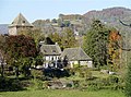
Attractions
- Saint-Martin church from the 12th / 13th centuries Century, monument historique since 1968
- 11th century Lescure Castle
- La Volpilhère castle from the 15th century
- Vigouroux castle from the 12th century

Saint Martin Church
Lescure Castle


Web links
Commons : Saint-Martin-sous-Vigouroux - Collection of images, videos and audio files