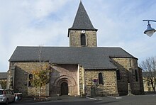
Vieillespesse
| Vieillespesse | ||
|---|---|---|
|
|
||
| region | Auvergne-Rhône-Alpes | |
| Department | Cantal | |
| Arrondissement | Saint-Flour | |
| Canton | Saint-Flour-1 | |
| Community association | Saint-Flour Community | |
| Coordinates | 45 ° 8 ' N , 3 ° 9' E | |
| height | 880-1,131 m | |
| surface | 24.91 km 2 | |
| Residents | 248 (January 1, 2017) | |
| Population density | 10 inhabitants / km 2 | |
| Post Code | 15500 | |
| INSEE code | 15259 | |
| Website | http://www.vieillespesse.fr/ | |
Vieillespesse is a central French city and a municipality with 248 inhabitants (as of January 1 2017) in the Cantal in the region of Auvergne Rhône-Alpes . The municipality belongs to the arrondissement Saint-Flour and the canton Saint-Flour-1 (until 2015: Canton Saint-Flour-Nord ).
location
Vieillespesse is about 59 kilometers east-northeast of Aurillac am Arcueil . Vieillespesse is surrounded by the neighboring communities of Saint-Mary-le-Plain in the north, Saint-Poncy in the north and northeast, Lastic in the east and southeast, Tiviers in the south and southeast, Mentières in the south, Coren in the south and southwest and Rézentières in the west and Northwest.
The A75 autoroute runs through the municipality .
Population development
| year | 1962 | 1968 | 1975 | 1982 | 1990 | 1999 | 2006 | 2013 |
| Residents | 375 | 347 | 317 | 302 | 254 | 248 | 252 | 268 |
| Source: Cassini and INSEE | ||||||||
Attractions
- Saint-Sulpice church from the 12th century, alterations up to the 15th century
Web links
Commons : Vieillespesse - collection of images, videos and audio files

