Santoire
| Santoire | ||
|
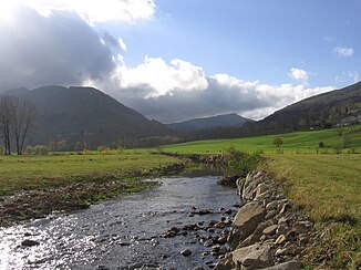
Upper course in the mountains |
||
| Data | ||
| Water code | FR : P03-0400 | |
| location | France , Auvergne-Rhône-Alpes region | |
| River system | Dordogne | |
| Drain over | Rhue → Dordogne → Atlantic Ocean | |
| source | in the municipality of Lavigerie 45 ° 6 ′ 9 ″ N , 2 ° 43 ′ 57 ″ E |
|
| Source height | approx. 1600 m | |
| muzzle | opposite Condat in the Rhue coordinates: 45 ° 20 ′ 14 ″ N , 2 ° 44 ′ 57 ″ E 45 ° 20 ′ 14 ″ N , 2 ° 44 ′ 57 ″ E |
|
| Mouth height | approx. 695 m | |
| Height difference | approx. 905 m | |
| Bottom slope | approx. 22 ‰ | |
| length | 41 km | |
| Catchment area | 169 km² | |
The Santoire is a river in France in the Auvergne-Rhône-Alpes region . It rises in the municipality of Lavigerie . The source is located in the Volcans d'Auvergne Regional Nature Park , at the Puy Bataillouse . The Santoire generally drains to the north, flows through the western foothills of the Massif Central and flows into the Rhue after 41 kilometers opposite Condat as a left tributary .
Places on the river
Web links
Commons : Santoire - Collection of images, videos and audio files
