La Giettaz
| La Giettaz | ||
|---|---|---|
|
|
||
| region | Auvergne-Rhône-Alpes | |
| Department | Savoie | |
| Arrondissement | Albertville | |
| Canton | Ugine | |
| Community association | Arlysere | |
| Coordinates | 45 ° 52 ′ N , 6 ° 30 ′ E | |
| height | 1,002-2,611 m | |
| surface | 35.2 km 2 | |
| Residents | 403 (January 1, 2017) | |
| Population density | 11 inhabitants / km 2 | |
| Post Code | 73590 | |
| INSEE code | 73123 | |
| Website | www.mairie-la-giettaz.fr | |
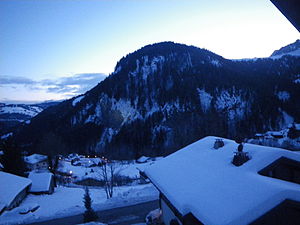
 The village of La Giettaz at dusk |
||
La Giettaz [ laʒiɛtɐ even laʒiɛt ] is a commune with 403 inhabitants (at January 1, 2017) in the Savoie department in the region of Auvergne Rhône-Alpes . It belongs to the canton of Ugine in the arrondissement of Albertville .
geography
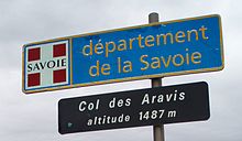
La Giettaz is the northernmost municipality in the Savoie department. It is located at around 1100 m in a valley basin of the Massif des Aravis , at the confluence of the Torrent des Aravis with the Arrondine , a tributary of the Arly . The Chaîne des Aravis mountain range , the central elevation of the mountain range, rises to the west of the municipality . It is from the Pass of the Aravis Col in 1487 m intersected height, crosses the La Giettaz from a road. In a southerly direction, the capital of the canton of Ugine is 20 km and the city of Albertville is 28 km . La Giettaz is also 45 km east of Annecy and 62 km southeast of Geneva .
The neighboring communities (clockwise) are Flumet and Saint-Nicolas-la-Chapelle in the Savoie department to the south , and Manigod , La Clusaz , Cordon , Megève and Praz-sur-Arly in Haute-Savoie . The municipality of La Giettaz extends up to the ridges of the surrounding mountains and rises steeply. The highest point is near the 2616 m high peak of La Grande Balmaz . The municipality also includes the hamlet of Le Plan located upstream in the Arrondine valley at 1225 m .
population
With 403 inhabitants (as of January 1, 2017), La Giettaz is one of the small communities in the Savoie department. The population remained very constant for two centuries and even fell slightly. In doing so, La Giettaz did not follow the general population growth in the département during the last century or the access of residents caused elsewhere by alpine tourism. The locals of La Giettaz are called Giettois (es) in French .
| year | 1800 | 1836 | 1866 | 1901 | 1921 | 1946 | 1962 | 1982 | 1990 | 1999 | 2006 | 2011 |
| Residents | 738 | 701 | 672 | 648 | 520 | 469 | 472 | 475 | 506 | 488 | 458 | 439 |
history
Finds of Roman boundary stones on the passes Col du Jaillet and Col de l'Avenaz between La Giettaz and the northeastern Cordon mark the border between Ceutron and Allobrogern and prove that the settlement was at least so strong that border traffic and responsibilities for the management of the alpine meadows had to be regulated. The place itself was first mentioned in 1307 as via agietarum . The establishment of its own church happened in 1390.
As a village in the Massif des Aravis , La Giettaz shared the history of Savoy . During the French Revolution , the peaceful idyll of the villagers, who are closely connected to the Catholic faith, suddenly became the focus of de-Christianization . As a result of the coalition war that broke out , the residents were forced to deliver the bells of the Saint-Pierre-aux-Liens church to be melted down and - as a visible sign in the fight against religion - to tear down the bell tower at the same time. It was not until 1846 that the funds were available to replace the dilapidated church building with the current structure and a new bell tower.
In the course of the complete occupation of France by the Axis Powers in World War II, Italian troops first occupied the village. In the months that followed, there were several house searches by the milice and the German occupiers in order to act against the resistance movement and to deport some of the Jews hidden in the village.
The first ski lift found its way into La Giettaz in 1953, and in 1970 the slope east of Le Plan , where today's ski area is located, began. The steep slopes around the village make an avalanche danger that occurs in winter often a danger for the residents themselves. Regular avalanches with buried houses and fatalities are attested again and again.
Origin of name
The place name La Giettaz follows the Franco-Provençal spelling , in which the -z is not pronounced, but shifts the stress to the penultimate syllable. Its meaning is less clear; there are several very contradicting conjectures. So there was probably the word gieta for gîte d'alpage in the Franco-Provencal dialect, i.e. an alpine hut or shelter on the mountain meadows. It is seen as the origin of several mountain huts and hamlets with the same or similar names. Another source suspects that the name describes the practice of hauling wood from the mountain slopes over steep gullies to the valley. A third source knows a medieval mention of the place as via agietarum and uses it to construct a diminutive of the Franco-Provencal word agi for hedge.
Partner municipality
- Treffléan (France, Brittany region )
Culture and sights
The most important building in La Giettaz is the Saint-Pierre-aux-Liens church , which the residents built between 1846 and 1860 to replace an older church. Its altarpiece and decorations are made in the baroque style.
Since 1995, a small museum in an old stone house has been showing antique objects from household use, workshops and the beginnings of winter sports, as well as traditional costumes, under the title A la rencontre du passé (for example: Walking towards the past).
Economy and Infrastructure
With 32 farms, which represent more than 20% of the farms, La Giettaz is much more agricultural than comparable communities in the vicinity (status 2000, INSEE). Regional cheeses are produced as an essential product of agriculture, namely Chevrotin , Beaufort , Reblochon and Tomme de Savoie . Unemployment is low and reaches values of a few percent. The town has three hotels, but tourism prefers second homes and holiday apartments, which together make up 71% of the 732 residential units.
traffic
La Giettaz can only be reached by one road, the D909 department road. As a connection between Flumet in the Val d'Arly and La Clusaz , it runs through the village and over the Col des Aravis . This road, which runs across the high alpine valleys, is a section of the approximately 700 km long Route des Grandes Alpes , which is particularly popular with tourists and cyclists. Within the municipality, the D132 still connects La Giettaz with the hamlet of Le Plan . The closest possible motorway connections are the A430 (Albertville exit, 28 km away) and the A40 (exits 20 to 22, around 27 km away). The Albertville SNCF train station is suitable for reaching La Giettaz by bus. Airports in the region are Geneva (70 km), Chambéry-Savoie (90 km) and Lyon-St-Exupéry (160 km).
education
In La Giettaz there is a state École primaire , i. H. a primary school with an attached kindergarten.
Sports
Since 1911 , one of the mountain stages of the Tour de France has regularly led over the Col des Aravis and then inevitably passes the place. In the 100 years between 1911 and 2010, the Tour de France has passed through La Giettaz 39 times.
Every year in June, La Giettaz organizes the one-week Aravis Bike Tour ( Giettoise Bike Week until 2014 ) and thus offers a framework event for cyclists who prefer mountain routes and especially the Col des Aravis .
The northern slopes of the Tête du Torraz mountain are accessible with cable cars and ski slopes in the area of the hamlet Le Plan . Together with the lifts in the municipalities of Combloux and Cordon as well as the Le Jaillet slope in Megève, they form the Les Portes du Mont-Blanc ski area with a total of just over 100 km of slopes in all levels of difficulty. The altitude between 1190 m and 1930 m give the ski area a rural character, as the slopes lead through forests, mountain meadows and past mountain huts. The Portes du Mont-Blanc are in turn connected to the Evasion Mont-Blanc ski area .
Web links
- Official website of the municipality of La Giettaz
- Website of the La Giettaz et son Patrimoine association
- Website of the La Giettaz Tourist Office
- Les Portes du Mont-Blanc ski area
- Aravis Bike Tour
Individual evidence
- ↑ French Statistics Institute ( www.insee.fr )
- ↑ La Giettaz - notice communale. In: cassini.ehess.fr. Retrieved on August 12, 2014 (French, INSEE population from 1968 ).
- ^ Culture & patrimoine à Cordon. In: Website of the Mairie of Cordon. Retrieved August 12, 2014 (French).
- ^ Borne frontière romaine dite Fines in the Base Mérimée of the French Ministry of Culture (French).
- ^ A b Ernest Nègre: Toponymie générale de la France . tape 2 . Librairie Droz, 1991, ISBN 2-600-00133-6 , pp. 1355 (French, limited preview in Google Book search).
- ↑ Secrets de clocher (1999). In: Website La Giettaz et son patrimoine . Retrieved August 12, 2014 (French).
- ↑ 50 ans après, souvenons-nous (1995). In: Website La Giettaz et son patrimoine . Retrieved August 12, 2014 (French).
- ↑ http://www.remontees-mecaniques.net/forums/index.php?showtopic=13460 , accessed in September 2012.
- ↑ Où sont les neiges d'antan? (1999). In: Website La Giettaz et son patrimoine . Retrieved August 12, 2014 (French).
- ↑ A. Pégorier, Les Noms des lieux en France (PDF; 2.5 MB) Institut Géographique National 2006, accessed in September 2012.
- ↑ Ch. Marteaux Sur le sens et l'étymologie de quelques noms et lieux Savoyards , in Recueil des travaux de l'institut de géographie alpine, 1918.
- ↑ Présentation du musée (2007). In: Website La Giettaz et son patrimoine . Retrieved August 12, 2014 (French).
- ↑ Statistique dossier on La Giettaz from INSEE , accessed on August 2, 2019 from www.insee.fr.

