
Treffléan
|
Treffléan Trevlean |
||
|---|---|---|

|
|
|
| region | Brittany | |
| Department | Morbihan | |
| Arrondissement | Vannes | |
| Canton | Vannes-3 | |
| Community association | Golfe du Morbihan - Vannes Agglomération | |
| Coordinates | 47 ° 41 ′ N , 2 ° 37 ′ W | |
| height | 20-147 m | |
| surface | 18.26 km 2 | |
| Residents | 2,324 (January 1, 2017) | |
| Population density | 127 inhabitants / km 2 | |
| Post Code | 56250 | |
| INSEE code | 56255 | |
| Website | http://www.trefflean.com/ | |
 The village church in Treffléan |
||

Treffléan ( Breton Trevlean ) is a French municipality with 2,324 inhabitants (at January 1, 2017) in the department of Morbihan in the region of Brittany .
geography
Treffléan is located a little more than eleven kilometers northeast of Vannes in the center of the department. Neighboring communities are Elven in the north and northeast, Sulniac in the east, the Commune nouvelle Theix-Noyalo in the south and southwest and Saint-Nolff in the northwest.
history
There is little evidence of the early history of the community. Remains from prehistoric and Gallo-Roman times prove an early settlement. The Notre-Dame de Bon-Secours chapel in Cran is mentioned in a bull by Pope Clement V in 1309. Otherwise little is known about the medieval history of the place. Historically, the community belongs to the Pays de Vannes ( Bro-Gwened in Breton ). After the French Revolution , it was a combat zone between Republican troops and the Chouans. Politically, Treffléan became a municipality in 1790. From 1793 on, Treffléan belonged to the district of Vannes. From 1801 it was part of the arrondissement of Vannes and from 1801 to 2015 a municipality in the canton of Elven .
Population development
The population fell sharply between 1793 and 1800, and then grew sharply until 1821. In the following ten years it fell by almost 100 residents. This was followed by a period of stagnation with population numbers between 750 and 800 people until the beginning of the First World War. Because of the war casualties and the flu outbreak, it sank slightly until 1921. The population remained at the same level for a decade. An emigration phase followed from 1931, which ended in 1962. The proximity to the city of Vannes has been noticeable since 1962. Apart from a standstill in the 1990s, the population is growing continuously (1962–2012: +265%). The development:
| year | 1793 | 1800 | 1821 | 1831 | 1911 | 1921 | 1931 | 1962 | 1968 | 1975 | 1982 | 1990 | 1999 | 2006 | 2012 |
| Residents | 681 | 568 | 831 | 748 | 763 | 714 | 712 | 564 | 591 | 705 | 1144 | 1441 | 1445 | 1807 | 2058 |
Attractions
There are numerous attractions in the municipality:
- Saint-Léon village church (16th century; restored in 1840); with Kalvarienberg (17th century), enclosed spring and cross in the village cemetery
- Church Saint-Jean-Baptiste in Bizole (17th century); with the tombstone of Pastor Yves Pichon (1733) and six Lec'h on the south side of the church
- Notre-Dame de Bon-Secours chapel in Cran (13th-16th centuries)
- Sainte-Appoline Chapel (18th century) near Kerdréan; with a cased spring from the 17th century
- Saint-Mathieu chapel from the 16th century
- Gathered spring in Cran
- Contained spring Sainte-Juliette from 1666
- Mansions of Cran and Randrecart
- 16th century oven in Cran
- Mills in Cran and Randrecart
See also: List of the Monuments historiques in Treffléan
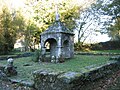
Gathered spring in Cran

Church Saint-Jean-Baptiste in Bizole

Notre-Dame de Bon-Secours chapel in Cran


literature
- Le Patrimoine des Communes du Morbihan. Flohic Editions, Volume 1, Paris 1996, ISBN 2-84234-009-4 , pp. 226-229.
Individual evidence
- ↑ Information on the sights of the community ( Memento of the original from June 22, 2015 in the Internet Archive ) Info: The archive link has been inserted automatically and has not yet been checked. Please check the original and archive link according to the instructions and then remove this notice.