
Saint-Marcel (Morbihan)
|
Saint-Marcel Saent-Marcèu |
||
|---|---|---|
|
||
| region | Brittany | |
| Department | Morbihan | |
| Arrondissement | Vannes | |
| Canton | Moréac | |
| Community association | De l'Oust à Brocéliande Communauté | |
| Coordinates | 47 ° 48 ′ N , 2 ° 25 ′ W | |
| height | 12-112 m | |
| surface | 12.81 km 2 | |
| Residents | 1,074 (January 1, 2017) | |
| Population density | 84 inhabitants / km 2 | |
| Post Code | 56140 | |
| INSEE code | 56228 | |
 the town hall (Mairie) of Saint-Marcel |
||

Saint-Marcel ( Gallo Saent-Marcèu , Breton Sant-Marc'hell ) is a French municipality with 1,074 inhabitants (at January 1, 2017) in the department of Morbihan in the region of Brittany .
geography
Saint-Marcel is located around 31 kilometers northeast of Vannes in the east of the Morbihan department. Neighboring communities are Saint-Abraham in the north, Missiriac in the northeast, Malestroit in the east, Pleucadeuc in the southeast, Bohal in the southwest and Sérent in the west.
Not far is the Allée couverte from Trélan .
Population development
| 1793 | 1831 | 1906 | 1962 | 1968 | 1975 | 1982 | 1990 | 1999 | 2006 | 2012 | ||
|---|---|---|---|---|---|---|---|---|---|---|---|---|
| 466 | 388 | 562 | 581 | 558 | 560 | 732 | 845 | 854 | 951 | 1051 | ||
| Sources: Cassini and INSEE | ||||||||||||
Attractions
See: List of Monuments historiques in Saint-Marcel (Morbihan)

Croix Catherine wayside cross
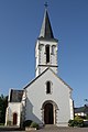
Saint-Marcel village church

Croix du Champ-des-Morts memorial cross

Stela in memory of killed resistance fighters


literature
- Le Patrimoine des Communes du Morbihan. Flohic Editions, Volume 2, Paris 1996, ISBN 2-84234-009-4 , pp. 580-583.
Web links
Commons : Saint-Marcel - Collection of images, videos and audio files