
Penestin
| Penestin | ||
|---|---|---|
.svg)
|
|
|
| region | Brittany | |
| Department | Morbihan | |
| Arrondissement | Vannes | |
| Canton | Muzillac | |
| Community association | Presqu'île de Guérande Atlantique | |
| Coordinates | 47 ° 29 ′ N , 2 ° 28 ′ W | |
| height | 0-38 m | |
| surface | 21.69 km 2 | |
| Residents | 1,946 (January 1, 2017) | |
| Population density | 90 inhabitants / km 2 | |
| Post Code | 56760 | |
| INSEE code | 56155 | |
| Website | http://www.mairie-penestin.com/ | |

Pénestin , Breton Penn Sandestin is a municipality in the department of Morbihan in the region of Brittany in northwest France . It belongs to the Communauté d'agglomération de la Presqu'île de Guérande Atlantique .
location
The town with 1946 inhabitants (as of January 1, 2017) is located on a peninsula between the mouths of the Vilaine rivers in the north and the Loire in the south. The historically significant Guérande is located on the same peninsula, in the neighboring region of Pays de la Loire . The border with the Pays de la Loire and the Loire-Atlantique department runs barely three kilometers south-east.
Residents of larger inland cities such as Nantes or Rennes have holiday and weekend homes in Pénestin. Most of these are rented to vacationers. Due to the location on the coast and nearby tourist destinations, the demand is very high.
The district extends from sea level to 38 m above sea level.
history
The parish was founded in 1790. Traditionally, Pénestin belonged to the parish of Assérac in Pays de la Loire. Although it had more to do with the communities further south , just like the neighboring villages of Camoël and Férel , the three localities fell to the Morbihan department.
| 1962 | 1968 | 1975 | 1982 | 1989 | 1999 | 2006 |
|---|---|---|---|---|---|---|
| 1031 | 1078 | 1192 | 1299 | 1394 | 1527 | 1777 |
Attractions
The beach section Plage de la Mine d'Or by Penestin is a natural heritage and is a geological feature. Various layers of earth such as mica slate, sand, clay and kaolin were deposited there. This porous layer forms a yellow to ocher colored cliff. The Méarzenne dolmen in Pénestin appears to have been used as a quarry. The place is mentioned in the book by Jean-François Polo and Élizabeth Santagreu 100 menhirs and dolmens on the Guérandaise peninsula and in the Brière . The authors say that there were eight tumuli and one large dolmen here in the past . The approximately 2.0 × 1.4 × 0.5 m measuring Menhir du Halguen still stands northwest of the village. The Île à Bacchus near the Pointe du Bile, with an ibis colony, belongs to the municipality .
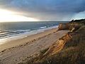
Penestin Beach

Liesegang rings on the cliffs

Île à Bacchus


literature
- Le Patrimoine des Communes du Morbihan. Flohic Editions, Volume 2, Paris 1996, ISBN 2-84234-009-4 , pp. 871-872.
Web links
Individual evidence
- Geo Sciences Uni Rennes (French)