
Guérande
| Guérande | ||
|---|---|---|

|
|
|
| region | Pays de la Loire | |
| Department | Loire-Atlantique | |
| Arrondissement | Saint-Nazaire | |
| Canton | Guérande (main town) | |
| Community association | Presqu'île de Guérande Atlantique | |
| Coordinates | 47 ° 20 ′ N , 2 ° 26 ′ W | |
| height | 0-60 m | |
| surface | 81.44 km 2 | |
| Residents | 15,873 (January 1, 2017) | |
| Population density | 195 inhabitants / km 2 | |
| Post Code | 44350 | |
| INSEE code | 44069 | |
| Website | www.mairie-guerande.fr | |

Guérande ( in Breton : Gwenrann ) is the historic Brittany associated commune in the Loire-Atlantique in the Region Pays de la Loire . It is located on the peninsula of the same name near the Atlantic coast and is best known for its historic town center with its largely preserved city wall from the Middle Ages and the fleur de sel , which is extracted in the Guerande salt pans .
geography
Guérande has 15,873 inhabitants (as of January 1, 2017) and consists of 32 villages and 72 hamlets, which are spread over an area of 8144 hectares . Around 300 hectares are forested, the salt fields take up around 2000 hectares, and 16 hectares are covered by water (ponds and canals). Some of these belong to the Brière Regional Nature Park ( French Parc naturel régional de Brière ).
history
Settlement of the Guérande peninsula dates back to the Neolithic , as evidenced by megaliths that are still present today . The city did not gain until the Middle Ages. Around the year 848 it temporarily became a bishopric. After 1343 the city began to be massively fortified. The work on the city wall dragged on for over a century. It was only inaugurated in 1488 by Duke Francois II of Brittany, the father of Anne de Bretagne .
The wealth of the medieval city was based on the salt production on the Guérande peninsula. The salt marshes on the coast are still in use today. Guerande is one of the few places in the world where the particularly precious sea salt Fleur de Sel is extracted. On hot days it falls out as a thin layer on the surface of the water and is skimmed off from there. The salt extracted from the ponds, on the other hand, is less pure and cheaper.
The Breton part of the name Gwen / guen , which means "white" , also points to the salt .
Culture and sights
- City wall from the 14th and 15th centuries
The city wall extends over a length of 1,434 meters and has four gates ( St. Michel in the east, Vannetaise in the north, Bizienne in the west and de Saillé in the south).
- The Saint-Aubin Collegiate Church
The church was built between the 12th and 16th centuries and has been classified as a Monument historique since 1853 .
- Museum of the Pays de Guérande
The museum is located in St. Michel , the main gate to the medieval city center, a building from the 15th century. Regional and local history is shown on three floors.
- The Guérande salt
The “white gold” (sea salt) is extracted in the salt marshes, the marais salants . In the small town of Batz-sur-Mer on the Atlantic coast, south of Guérande, the history and technology of salt extraction are presented in the Musée des Marais Salants .
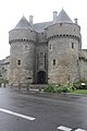
City gate Porte St. Michel
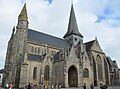
St. Aubin's collegiate church south side

Medieval city wall

Salt production on the Guérande peninsula

Moulin de Crémeur of the "petit-pied" type
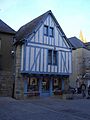
Half-timbered house

.jpg)


Town twinning
Since 1962/63 there has been a twinning between Guérande and the Middle Franconian town of Dinkelsbühl in Bavaria . The contacts go back to the 1950s. There are also partnerships with Dolgellau in Wales and Castro Marim in the Algarve (Portugal)
Movie
- Barefoot in the salt - the salt farmers of Brittany. Documentary, Germany, 2001, 43 min., Script and direction: Birgit Köster and Heidrun Seeger, production: Interface, WDR , table of contents and online video.
Personalities
- Sandrine Josso (* 1975), politician
literature
- Le Patrimoine des Communes de la Loire-Atlantique . Flohic Editions, Volume 1, Charenton-le-Pont 1999, ISBN 2-84234-040-X , pp. 415-433.
Web links
- Guérande Tourist Office (French)
- Geography of Brittany, portal for cities and regions in Brittany - Guérande / Gwenrann (French)
Individual evidence
- ^ William BS Smith: De la Toponymie Bretonne. Dictionnaire Etymologique. Language Monograph No. 20, Linguistic Society of America, Baltimore 1940, p. 59