Herbignac
| Herbignac | ||
|---|---|---|

|
|
|
| region | Pays de la Loire | |
| Department | Loire-Atlantique | |
| Arrondissement | Saint-Nazaire | |
| Canton | Guérande | |
| Community association | Presqu'île de Guérande Atlantique | |
| Coordinates | 47 ° 27 ′ N , 2 ° 19 ′ W | |
| height | 0-55 m | |
| surface | 71.43 km 2 | |
| Residents | 6,822 (January 1, 2017) | |
| Population density | 96 inhabitants / km 2 | |
| Post Code | 44410 | |
| INSEE code | 44072 | |
| Website | http://www.herbignac.com/ | |
 Location of the municipality of Herbignac in the Loire-Atlantique department |
||
Herbignac ( Breton Erbigneg ) is a French municipality with 6822 inhabitants (at January 1, 2017) in the Loire-Atlantique in the Region Pays de la Loire . Herbignac belongs to the canton of Guérande and was the main town (French: chef-lieu ) of the canton of Herbignac until 2015 .
geography
Herbignac is located in the northwest of the department near the Brière marshland and lagoon landscape , 16 kilometers north of Guérande and nine kilometers south of La Roche-Bernard . The municipality is part of the Brière Regional Nature Park .
In 1999, INSEE classified Herbignac as a commune rurale monopolarisée in the aire urbaine Saint-Nazaire in the espace urbain Nantes- Saint-Nazaire.
The two districts of Marlais and Pompas belong to Herbignac.
history
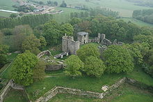
Around 1125 local lords erected a moth . It was replaced in the 13th century by the Château de Ranrouët, built under Alain d'Assérac .
During the Chouannerie , republican forces destroyed the castle in 1793 and executed many insurgents on the peninsula of La Baule and Guérande. Eventually the castle ruins were released as a quarry.
While at the end of the Second World War Nantes had been conquered by the Allies on August 12, 1944 and landscapes south of the Loire on August 30, 1944, the German troops handed over the fortress of St. Nazaire and with it Herbignac on May 11, 1945 in a ceremony American units ceremony. The handover took place three days after the German surrender in order to clear the mined access to the fortress.
Population development
After around 2,000 inhabitants around 1800, the number of inhabitants rose to 4,219 by 1891. The population then decreased to around 3,000 people by 1954, since around 1970 the population has increased again and in 2009 was 5,581.
education
In Herbignac there are two public schools and a private one, as well as a private and a public collège .
literature
- Le Patrimoine des Communes de la Loire-Atlantique . Flohic Editions, Volume 1, Charenton-le-Pont 1999, ISBN 2-84234-040-X , pp. 461-469.
Web links
Individual evidence
- ↑ a b Loire-Atlantique, le magazine du département , June 2009 edition; Pp. 20-21.
-
↑ "Grand Blockhaus" website (French / English).
Michel Gautier: Histoire de la poche de Saint-Nazaire ; 2010 (French).


