Saint-Armel (Morbihan)
|
Saint-Armel Sant-Armael |
||
|---|---|---|

|
|
|
| region | Brittany | |
| Department | Morbihan | |
| Arrondissement | Vannes | |
| Canton | Séné | |
| Community association | Golfe du Morbihan - Vannes Agglomération | |
| Coordinates | 47 ° 34 ′ N , 2 ° 43 ′ W | |
| height | 0-17 m | |
| surface | 7.95 km 2 | |
| Residents | 886 (January 1, 2017) | |
| Population density | 111 inhabitants / km 2 | |
| Post Code | 56450 | |
| INSEE code | 56205 | |
| Website | http://www.mairie-saint-armel.fr/ | |
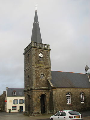
 The village church of Saint-Armel |
||
Saint-Armel ( Breton Sant-Armael ) is a French municipality with 886 inhabitants (at January 1, 2017) in the department of Morbihan in the region of Brittany .
geography
Saint-Armel is located in the south of the Morbihan department. It is about ten kilometers (as the crow flies) to Vannes . Neighboring communities are Séné in the north, Le Hézo in the northeast, Sarzeau in the south and the Gulf of Morbihan in the west. The municipality includes the islands of Île Tascon and Île Bailleron .
Population development
| year | 1962 | 1968 | 1975 | 1982 | 1990 | 1999 | 2006 | 2012 |
| Residents | 305 | 270 | 295 | 500 | 661 | 707 | 796 | 861 |
Attractions
- Village church Sainte-Armel (built 1855-1859)
- Le Mené mansion from the 16th century
- 18th century farmhouse on Tascon Island
- House from 1781
- Watermill in La Motte
- Islands
- Lasné and Ludré wetlands
literature
- Le Patrimoine des Communes du Morbihan. Flohic Editions, Volume 2, Paris 1996, ISBN 2-84234-009-4 , pp. 954-955.
Web links
Commons : Saint-Armel - Collection of images, videos and audio files

