
Monterblanc
|
Monterblanc Sterwenn |
||
|---|---|---|
.svg)
|
|
|
| region | Brittany | |
| Department | Morbihan | |
| Arrondissement | Vannes | |
| Canton | Vannes-3 | |
| Community association | Golfe du Morbihan - Vannes Agglomération | |
| Coordinates | 47 ° 45 ′ N , 2 ° 41 ′ W | |
| height | 46-151 m | |
| surface | 25.41 km 2 | |
| Residents | 3,275 (January 1, 2017) | |
| Population density | 129 inhabitants / km 2 | |
| Post Code | 56250 | |
| INSEE code | 56137 | |
| Website | http://www.monterblanc.fr/ | |
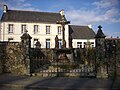
 The Mairie (Municipal Council) of Monterblanc |
||

Monterblanc ( Breton Sterwenn ) is a French municipality with 3,275 inhabitants (at January 1, 2017) in the department of Morbihan in the region of Brittany .
geography
Monterblanc is located a little more than eleven kilometers northeast of Vannes in the center of the department. Neighboring communities are Plaudren in the north, Elven in the northeast, Saint-Nolff in the east and south, Saint-Avé in the south and west and Locqueltas in the north-west.
history
There is little evidence of the early history of the community. Remains from prehistoric and Gallo-Roman times prove an early settlement. The document collection of the Redon Abbey first mentions the place under the name Budwere on September 21, 852. In the Middle Ages, monks settled there. Their monastery became known as the White Monastery ( Moustoir Blanc ). This is how today's community name arose. The community was part of the extensive parish of Plaudren and the feudal lordship of Argoët. Historically, the community belongs to the Pays de Vannes ( Bro-Gwened in Breton ). After the French Revolution , it was a combat zone between Republican troops and the Chouans. Politically, Monterblanc became a parish in 1790. From 1793 on, Monterblanc belonged to the canton of Saint Avez and the district of Vannes. From 1801 it was part of the arrondissement of Vannes and from 1801 to 2015 a municipality in the canton of Elven .
Population development
The population increased sharply between 1793 and 1800, only to decrease sharply in the following six years. This was followed by a period of stagnation with population numbers of around 900 people with little growth (1800–1831). From 1856 to 1936 the number of residents fluctuated around the thousand mark. The only exception was the year 1926 with a uniquely high population. After a period of strong growth between 1936 and 1946, a phase of emigration followed, which ended in 1962. The proximity to the city of Vannes has been noticeable since 1962. The population continues to grow - apart from a small decline in the 1990s (1962–2012: +260%). The development:
| year | 1793 | 1800 | 1806 | 1841 | 1851 | 1926 | 1936 | 1946 | 1962 | 1968 | 1975 | 1982 | 1990 | 1999 | 2006 | 2012 |
| Residents | 831 | 944 | 894 | 913 | 1002 | 1531 | 1045 | 1327 | 896 | 1126 | 1386 | 1794 | 2006 | 1951 | 2542 | 3229 |
Attractions
See also: List of Monuments historiques in Monterblanc
- Saint-Pierre village church (18th century; restored in 1834 and 1990); with organ from 1853 and cased spring (17th century)
- Notre-Dame chapel (also by Mangolérian; from the 15th to 17th centuries) in Mangolérian ( statue of the Virgin Mary from the 12th century), with a calvary and a cased spring
- Old Castle or Coh Castel
- Watermills in Le Procureur and Largouet
- Windmill in Monterblanc
- Military camp, used today for training units for UN blue helmet operations
- Airfield (today for private planes, earlier for parachute units)

The Ytrac windmill in Monterblanc
The Calvary on Rue Joachim Lamour
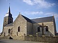
The Saint-Pierre village church

The Notre-Dame chapel in Mangolérian

.JPG)
.JPG)
.JPG)
literature
- Le Patrimoine des Communes du Morbihan. Flohic Editions, Volume 1, Paris 1996, ISBN 2-84234-009-4 , pp. 211-213.
Individual evidence
- ↑ Information on the sights of the community ( Memento of the original from April 2, 2015 in the Internet Archive ) Info: The archive link was inserted automatically and has not yet been checked. Please check the original and archive link according to the instructions and then remove this notice.