Île-aux-Moines
|
Île-aux-Moines Enizenac'h |
||
|---|---|---|

|
|
|
| region | Brittany | |
| Department | Morbihan | |
| Arrondissement | Vannes | |
| Canton | Vannes-2 | |
| Community association | Golfe du Morbihan - Vannes Agglomération | |
| Coordinates | 47 ° 36 ′ N , 2 ° 51 ′ W | |
| height | -1–31 m | |
| surface | 3.20 km 2 | |
| Residents | 606 (January 1, 2017) | |
| Population density | 189 inhabitants / km 2 | |
| Post Code | 56780 | |
| INSEE code | 56087 | |
| Website | http://www.mairie-ileauxmoines.fr/ | |
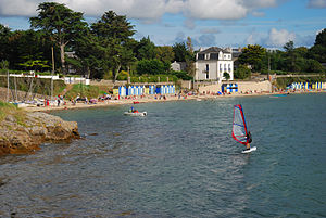
 Beach on the Île-aux-Moines |
||
The Île-aux-Moines ( Breton Izenah - German "island of the monks" ) is a French commune and the island of the same name in the Morbihan department in Brittany . The seven kilometer long and at one point five kilometers wide, roughly cruciform island has a size of about 3.1 km² and is one of the two island communities in the Gulf of Morbihan , along with the Île d'Arz . It also includes Île Creïzic and several other tiny islands.

Due to the cross shape, no point on the island is more than 450 meters from the sea. The island itself is also only 500 m from Port-Blanc on the mainland. From there and from Larmor-Baden it is possible to reach the largest island in the Gulf in about ten minutes. The wooded (figs, eucalyptus, camellias, mimosas, olive trees and pines) "Pearl of the Gulf" is a domicile for artists and a destination for tourists. The village has 606 inhabitants (as of January 1, 2017); this number is increased tenfold by summer house guests.
history
The Île-aux-Moines has been inhabited at least since the Neolithic . Evidence for this are four dolmens ( Kerno , Penhap and the dolmens of Pen-Nioul at the Pointe de Nioul), a menhir (near Brouel) and the Cromlech of Kergonan ; a stone circle about 101 m in diameter. The majority of the megalithic systems are concentrated in the southern half. The Penhap dolmen (also called by Boglieux) is the best preserved on the island. He has some tongue-shaped rock carvings , the axes represent, and a huge capstone.
The slightly oval cromlech of Kergonan is located in the village in the center of the island. With a radius of more than 100 m, it is the largest in France. Half of the stone circle fell victim to the development.
In 854, a donation from the Breton Duke Erispoe to the Abbey of Saint-Sauveur in Redon caused the monastery to be founded on the island from there. From the 10th century it belonged to the municipality of Arradon . In 1453 the place received the status of a municipality, which became independent in 1792.
literature
- Le Patrimoine des Communes du Morbihan. Flohic Editions, Volume 2, Paris 1996, ISBN 2-84234-009-4 , pp. 1006-1009.


