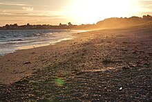
Damgan
| Damgan | ||
|---|---|---|

|
|
|
| region | Brittany | |
| Department | Morbihan | |
| Arrondissement | Vannes | |
| Canton | Muzillac | |
| Community association | Arc Sud Brittany | |
| Coordinates | 47 ° 31 ′ N , 2 ° 34 ′ W | |
| height | 0-20 m | |
| surface | 10.16 km 2 | |
| Residents | 1,702 (January 1, 2017) | |
| Population density | 168 inhabitants / km 2 | |
| Post Code | 56750 | |
| INSEE code | 56052 | |
| Website | http://www.damgan.fr | |
Damgan is a French commune with 1,702 inhabitants (at January 1, 2017) in the department of Morbihan in the region of Brittany . It is part of the Communauté de communes Arc Sud Bretagne .
location
Damgan lies on a peninsula between the mouth of the Penerf and the mouth of the Vilaine . To the west is the Rhuys peninsula , to the north is the municipality of Ambon .
Damgan has been known as a seaside resort since the beginning of the 20th century and has eight kilometers of sandy beach. The most important districts are the former fishing villages of Penerf and Kervoyal and the main town of Damgan.
Demographics
The population of Damgan parish is growing steadily, from 812 in 1962 to 1702 (January 1, 2017).
In 2007 there were 4055 residences in Damgan, including 3295 (= 81.3%) second residences, which are mostly only used during the summer months.
Architectural monuments
See: List of Monuments historiques in Damgan
Economy and Transport
tourism
The most important branch of the economy is tourism. There are overnight accommodations in two hotels, many private accommodations and more than 20 campsites. 97% of holidaymakers in 2009 (measured by the number of visitors to the tourist office) came from France.
Oyster farming
In addition to tourism, the municipality has a second economic pillar with oyster farming in the Pénerf estuary . The first oyster breeding parks were established here in 1858. Eight of these oyster farms are located in Penerf on the banks of the river of the same name.
traffic
Damgan is about seven kilometers south of the motorway-like N165, which leads from Nantes via Vannes , Lorient and Quimper to Brest . The closest train station is Questembert .
Damgan is connected to Le Tour du Parc by a bicycle ferry across the Penerf.
literature
- Le Patrimoine des Communes du Morbihan. Flohic Editions, Volume 2, Paris 1996, ISBN 2-84234-009-4 , pp. 618-621.
Web links
Individual evidence
- ^ Insee - Results du recensement de la population - 2007 Damgan . recensement.insee.fr. Retrieved on February 2, 2011. ( Page no longer available , search in web archives ) Info: The link was automatically marked as defective. Please check the link according to the instructions and then remove this notice.
- ↑ Site officiel de la mairie d 'Damgan - Bulletin municipale Vol. 61 (PDF; 9.3 MB) damgan.fr. Retrieved February 2, 2011.
- ^ Site officiel de la mairie d 'Damgan . damgan.fr. Archived from the original on August 4, 2012. Info: The archive link was automatically inserted and not yet checked. Please check the original and archive link according to the instructions and then remove this notice. Retrieved February 2, 2011.
- ^ Site officiel de la mairie d 'Damgan . damgan.fr. Retrieved February 2, 2011.
- ^ Site officiel de la mairie d 'Damgan . damgan.fr. Archived from the original on September 3, 2011. Info: The archive link was inserted automatically and has not yet been checked. Please check the original and archive link according to the instructions and then remove this notice. Retrieved June 27, 2011.

