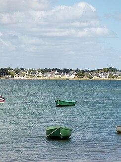
Penerf
| Penerf | ||
|
Estuary of the Penerf |
||
| Data | ||
| Water code | FR : J6514000 | |
| location | France , Brittany region | |
| River system | Penerf | |
| source | in the municipality of Berric 47 ° 38 ′ 57 ″ N , 2 ° 31 ′ 56 ″ W |
|
| Source height | approx. 100 m | |
| muzzle | on the municipal boundary of Le Tour-du-Parc and Damgan in the Atlantic Ocean Coordinates: 47 ° 30 ′ 38 " N , 2 ° 38 ′ 1" W 47 ° 30 ′ 38 " N , 2 ° 38 ′ 1" W |
|
| Mouth height | 0 m | |
| Height difference | approx. 100 m | |
| Bottom slope | approx. 4 ‰ | |
| length | 25 km | |
| Right tributaries | Épinay , Sarzeau | |
| Navigable | in the mouth section | |
The Penerf ( Rivière de Penerf , Breton Stêr Penerv ) is a river in France that runs in the Morbihan department in the Brittany region . It rises in the municipality of Berric , generally drains towards the southwest, changing its name several times ( Ruisseau du Guerhec, Ruisseau de la Drague ) and after 25 kilometers it flows into the Atlantic Ocean at the municipal boundary of Le Tour-du-Parc and Damgan . For the last six kilometers, the river is influenced by the tides and forms an estuary .
Places on the river
Natura 2000 area
The Penerf estuary, together with the Suscinio swamp, is a Natura 2000 area (area: 4924 ha). The most important landforms of this protected area are:
- Inlets: 38%
- Salt marshes and salt marshes: 22%
- rivers or estuaries, tidal flats and sandbanks depending on the tides: 13%
- (wet) pasture land: 14%
Oyster farming
The estuary is economically important as an oyster farming area . The first breeding parks were established in 1858. At that time the European oyster was bred here, which was later replaced by the Portuguese oyster . After a mass extinction around 1970, the Pacific rock oysters were introduced into the Penerf estuary . Today there are 53 farms here, cultivating 225 hectares.
Web links
Individual evidence
- ↑ a b geoportail.fr (1: 16,000)
- ↑ a b The information on the length of the river is based on the information about the Penerf at SANDRE (French), accessed on November 27, 2011, rounded to the nearest kilometer.
- ↑ Information about the Natura 2000 area
