Monthion
| Monthion | ||
|---|---|---|
|
|
||
| region | Auvergne-Rhône-Alpes | |
| Department | Savoie | |
| Arrondissement | Albertville | |
| Canton | Albertville-2 | |
| Community association | Arlysere | |
| Coordinates | 45 ° 38 ′ N , 6 ° 22 ′ E | |
| height | 319–2,048 m | |
| surface | 6.36 km 2 | |
| Residents | 550 (January 1, 2017) | |
| Population density | 86 inhabitants / km 2 | |
| Post Code | 73200 | |
| INSEE code | 73170 | |
| Website | www.monthion.com | |
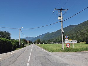
 The entrance to the town in the area of La Plaine de Monthion |
||
Monthion is a French municipality with 550 inhabitants (at January 1, 2017) in the department of Savoie in the region of Auvergne Rhône-Alpes . It belongs to the canton of Albertville-2 in the Albertville arrondissement .
geography
location
Monthion is located at 490 m , about 35 kilometers east-northeast of the prefecture of Chambéry and 65 kilometers south-southeast of the city of Geneva (as the crow flies). The neighboring municipalities of Monthion are Gilly-sur-Isère in the north, Grignon in the northeast, Esserts-Blay and Saint-Paul-sur-Isère (point of contact) in the east and Notre-Dame-des-Millères in the south and west.
topography
The area of the 6.36 km 2 municipality includes a narrow section in the middle Isère valley on the southern valley flank, a few kilometers downstream from the city of Albertville . The northernmost part with the district of La Plaine de Monthion is located on the flat valley floor about two kilometers from the banks of the Isère, the development today seamlessly connects to that of Grignon. At the edge of this plain, the communal soil rises abruptly and includes the northwest flank of the 2111 m high La Grande Lanche , an elevation in the northern foothills of the Grand Arc , the northernmost peak of the Vanoise Mountains . About 100 m above the level, the ascent is interrupted by a ledge on which the town center of Monthion and the part of Les Mery are located. A few farms and mountain huts still stand above the village. The mountain slope is drained by several small water channels towards the Isère, from which the Hermettaz mountain stream marks the western boundary of the municipality. With the mostly forested valley flank, the community has a forest share of 75.8%, followed by agriculturally used soils with 10% and alpine meadows with 8.2%.
history
In the Middle Ages, Curatus Moncyonis was first mentioned in the 14th century with reference to Monthiod. At the time of the Ancien Régime , the place belonged to the Baronnie of Sainte-Hélène-des-Millières .
Attractions
A hiking trail leads to the 2111 m high La Grande Lanche , from which there are views over the mountain massifs of the Bauges and Beaufortain as well as the entire bend of the Isère from the lower Tarentaise to the end of the Combe de Savoie . Monthion village church was built in the 19th century.
population
| Population development | |
|---|---|
| year | Residents |
| 1962 | 188 |
| 1968 | 185 |
| 1975 | 207 |
| 1982 | 194 |
| 1990 | 304 |
| 1999 | 370 |
| 2006 | 427 |
| 2011 | 487 |
With 550 inhabitants (as of January 1, 2017), Monthion is one of the small communities in the Savoie department. After the number of inhabitants declined in the first half of the 20th century (around 300 inhabitants were regularly counted in the 19th century), the population has increased again since the early 1990s. The locals of Monthion are called Monthionais (es) in French .
Economy and Infrastructure
Until well into the 20th century, Monthion was a village dominated by agriculture and forestry . In addition, there are now some local small businesses. Above all, the village has developed into a residential community whose employees go about their work in the larger towns in the area and especially in the Albertville area.
The department road D925 runs through the village and opens up from Albertville to the villages downstream on the left bank of the Isère. In the northern neighboring communities there are connections to the regional infrastructure in the Isère Valley, namely to the A430 motorway and the Saint-Pierre-d'Albigny – Bourg-Saint-Maurice railway line with a train station in Albertville. Chambéry-Savoie (distance 57 km) and Geneva (100 km) are possible airports in the region .
In Monthion there is a primary school ( école primaire ).
Web links
Individual evidence
- ↑ 2006 data from CORINE Land Cover , available e.g. B. at www.statistiques.developpement-durable.gouv.fr ( Memento of the original from March 24, 2016 in the Internet Archive ) Info: The archive link has been inserted automatically and has not yet been checked. Please check the original and archive link according to the instructions and then remove this notice. .
- ^ JJ Vernier: Dictionnaire topographique du département de la Savoie . Imprimerie Savoisienne, 1896, p. 525 (French, online on BNF [accessed January 19, 2014]).
- ↑ French Statistics Institute ( www.insee.fr )
- ^ Monthion - notice communale. In: cassini.ehess.fr. Retrieved March 20, 2015 (French).
- ^ Complete dossier on Monthion. In: INSEE . Retrieved on March 20, 2015 (French, INSEE population from 1968 ).
