Bozel
| Bozel | ||
|---|---|---|

|
|
|
| region | Auvergne-Rhône-Alpes | |
| Department | Savoie | |
| Arrondissement | Albertville | |
| Canton | Moûtiers | |
| Community association | Val Vanoise | |
| Coordinates | 45 ° 27 ' N , 6 ° 39' E | |
| height | 746-2,594 m | |
| surface | 28.8 km 2 | |
| Residents | 1,841 (January 1, 2017) | |
| Population density | 64 inhabitants / km 2 | |
| Post Code | 73350 | |
| INSEE code | 73055 | |
| Website | http://www.mairiebozel.fr/ | |
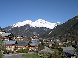
 Bozel with its parish church in the middle and the 3,398 m high Grand Bec in the background |
||
Bozel ( Franco-Provençal: Bozé ) is commune with 1,841 inhabitants (as of January 1 2017) in the department of Savoie in the region of Auvergne Rhône-Alpes . It belongs to the Arrondissement of Albertville and the Canton of Moûtiers . It is also the seat of the Val Vanoise Tarentaise municipal association .
geography
The community is located about 35 kilometers southwest of Albertville in the valley of the river Doron de Bozel . Neighboring communities are:
- Aime and Mâcot-la-Plagne in the north,
- Champagny-en-Vanoise in the northeast,
- Planay in the southeast,
- Saint-Bon-Tarentaise in the south,
- Montagny to the west and
- Notre-Dame-du-Pré in the north-west.
The highest point in the municipality is the mountain top of Dent du Villard at 2594 m. ü. Other elevations are the Villemartin (1116 m), the Trincave (1263 m), Les Mollinets (1111 m) and Le Ratelard et Lachenal (1350 m). The brook Bonrieu with its tributaries drains the area on the north side, crosses the municipal capital and flows into the Doron de Bozel on the southern outskirts .
history
At that time the village belonged to the historical province of Tarentaise and was called "Bosellis" around 1170, "Bossel" around 1691, "Bosselles" around 1759 and "Bozeil" around 1764.
Population development
| year | 1968 | 1975 | 1982 | 1990 | 1999 | 2006 | 2016 |
| Residents | 1,380 | 1,344 | 1,504 | 1,690 | 1,854 | 1,975 | 1,900 |
Web links
Individual evidence
- ^ JJ Vernier: Dictionnaire topographique du département de la Savoie . Imprimerie Savoisienne, 1896, p. 263 (French, online on BNF [accessed January 19, 2014]).
