
Mâcot-la-Plagne
| Mâcot-la-Plagne | ||
|---|---|---|
|
||
| local community | La Plagne-Tarentaise | |
| region | Auvergne-Rhône-Alpes | |
| Department | Savoie | |
| Arrondissement | Albertville | |
| Coordinates | 45 ° 33 ' N , 6 ° 40' E | |
| Post Code | 73210 | |
| Former INSEE code | 73150 | |
| Incorporation | January 1, 2016 | |
| status | Commune déléguée | |
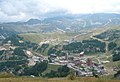
 Summer view of La Plagne |
||

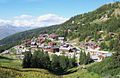
Mâcot-la-Plagne is a commune Déléguée with 1,697 inhabitants (at January 1, 2017) in the town of La Plagne-Tarentaise in the department of Savoie in the region of Auvergne Rhône-Alpes . It belonged to the arrondissement of Albertville and the canton of Bourg-Saint-Maurice . The place is the center of the La Plagne ski area and is heavily influenced by winter sports.
With effect from January 1, 2016, the former municipalities of Mâcot-la-Plagne , Bellentry , La Côte-d'Aime and Valezan were merged into a commune nouvelle called La Plagne Tarentaise.
geography
location
Mâcot-la-Plagne is located at 767 m , about 59 km east of the prefecture of Chambéry , 83 km south-southeast of the city of Geneva and 57 km southeast of the city of Annecy (as the crow flies). The village extends on a valley flank on the upper reaches of the Isère in the historic province of Tarentaise . Neighboring towns of Mâcot-la-Plagne are La Côte-d'Aime and Valézan in the north, Bellentre in the east, Champagny-en-Vanoise and Bozel in the south and Aime in the west.
In addition to the actual town center ( 770 m ), Mâcot-la-Plagne also included the eastern part of Sangot ( 803 m ) and several hamlet settlements and hotel complexes, including:
- Bonnegarde ( 740 m ) and Les Provenanges ( 684 m ) on the border with Aime;
- Le Villard-de-Sangot ( 978 m ), Les Esserts ( 1240 m ), Champs Drivet ( 1429 m ), Praz Salvard ( 1484 m ) and Plan Bois ( 1826 m ) on the eastern edge of the municipality;
- Les Chacruets ( 1009 m ), Les Granges ( 1451 m ) and Les Frasses ( 1790 m ) on the slope between the mountain streams of Sangot and Mâcot;
- Les Villards de Mâcot ( 1189 m ), Prariond ( 1341 m ), Plangagnant ( 1600 m ) and La Roche ( 1547 m ) on the road to La Plagne; such as
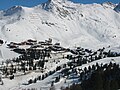
- The center of the winter sports area with the districts of La Plagne, Plagne 1800, Plagne Soleil, Plagne Bellecôte and Belle Plagne is located in a valley basin at around 1800 m on the north side of the chain of peaks stretched between Mont Jovet and Roche de Mio.
history
The Tarantaise was settled by the Celtic people of the Ceutrons before Roman times. The parish of Mâcot dates back to the High Middle Ages and was first mentioned in a document in 1096 ( Ecclesia de Mascot ). The name part Mâcot is traced back to a personal name, while Plagne refers to a small plain in the mountains. Various spelling variants appeared in the 17th and 18th centuries, including Mâcod , Maccot , Ma (r) coz and Macot-et-Sangot .
The history of the La Plagne ski area began with the 1961/1962 winter season and the first surface lifts were installed. In the 1970s it expanded to roughly what it is today, and in the following two decades many of the lifts were modernized.
Attractions
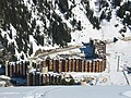
At Les Frasses at almost 1,800 m there is a barrow that is classified as a monument historique . It can be reached via a hiking trail.
Belle Plagne
Plagne Bellecote
Plagne 1800
Plagne Center


population
| Population development | |
|---|---|
| year | Residents |
| 1962 | 1,072 |
| 1968 | 1,204 |
| 1975 | 1,112 |
| 1982 | 1,210 |
| 1990 | 1,621 |
| 1999 | 1,578 |
| 2006 | 1,749 |
| 2011 | 1,817 |
After the population fell from 1,312 to 800 after the annexation of Savoy to France in the 19th century, it fluctuated by around 1,000 in the 20th century. Only with the success of winter sports at the end of the 20th century did the population increase significantly. The local residents of Mâcot-la-Plagne are called Mâcotais (es) in French .
Economy and Infrastructure
Mâcot-la-Plagne was until well into the 20th century a village characterized by agriculture , especially dairy farming . Today there are various local small businesses and many service providers in the village. Tourism with eight hotels and countless residential complexes has created a large number of jobs. Almost all employed people work in the town or in the immediate vicinity.
The village is not far from the N90 , the main and only access to the Tarentaise in winter. From the N90, a descent with a bridge over the Isère leads to the various parts of the municipality and a serpentine road (D 221) up to La Plagne. The N90 merges into the A430 motorway down the valley at Albertville . The nearest passenger station is in Aime on the Saint-Pierre-d'Albigny – Bourg-Saint-Maurice railway that crosses the municipality. Chambéry-Savoie (distance 102 km) and Geneva (161 km) are possible airports in the region .
education
In Mâcot-la-Plagne there are two primary schools ( école primaire ) with integrated preschool classes.
Web links
- Official website (French)
Individual evidence
- ↑ A. Gros: Dictionnaire étymologique des noms de lieu de la Savoie . Belley, Imprimerie Aimé Chaduc, 1937, p. 259, 260, 355 (French, limited preview in Google Book search).
- ^ JJ Vernier: Dictionnaire topographique du département de la Savoie . Imprimerie Savoisienne, 1896, p. 483 (French, online on BNF [accessed January 19, 2014]).
- ^ Romain Guigon: Une Histoire de La Plagne. In: perso-laplagne.fr. Retrieved October 9, 2015 .
- ^ Dolmen in the Base Mérimée of the French Ministry of Culture (French).
- ^ Mâcot-la-Plagne - notice communale. In: cassini.ehess.fr. Retrieved September 28, 2015 (French, INSEE population from 1968 ).
- ↑ Commune de Mâcot-la-Plagne - Dossier complet. In: INSEE . Retrieved September 28, 2015 (French).