
Aime-la-Plagne
| Aime-la-Plagne | ||
|---|---|---|
|
||
| region | Auvergne-Rhône-Alpes | |
| Department | Savoie | |
| Arrondissement | Albertville | |
| Canton | Bourg-Saint-Maurice | |
| Community association | Les Versants d'Aime | |
| Coordinates | 45 ° 34 ' N , 6 ° 39' E | |
| height | 556-2,700 m | |
| surface | 94.67 km 2 | |
| Residents | 4,443 (January 1, 2017) | |
| Population density | 47 inhabitants / km 2 | |
| Post Code | 73210 | |
| INSEE code | 73006 | |
| Website | http://www.ville-aime.fr/ | |
.JPG) Aerial view of Aime |
||

Aime la Plagne is a French commune with 4,443 inhabitants (as of January 1 2017) in the department of Savoie in the region of Auvergne Rhône-Alpes . It belongs to the arrondissement of Albertville and the canton of Bourg-Saint-Maurice .
Geographical location
Aime-la-Plagne is located around 29 kilometers southeast of Albertville in the Tarentaise . The Isère runs through the municipality . Aime-la-Plagne is surrounded by the neighboring communities of Beaufort in the north, La Plagne Tarentaise in the east and northeast, Bozel and Notre-Dame-du-Pré in the south, Hautecour in the west and southwest and La Léchère in the west.
The National Route 90 runs through the municipality .
history
On January 1, 2016, Aime-la-Plagne was formed as Commune nouvelle from the previously independent municipalities of Aime , Granier and Montgirod .
structure
| District | former INSEE code |
Area (km²) | Population (2016) |
|---|---|---|---|
| Aime (administrative headquarters) | 73006 | 50.74 | 3,598 |
| Granier | 73126 | 30.31 | 355 |
| Montgirod | 73169 | 13.62 | 478 |
Attractions
Aime
- Saint-Martin Basilica, Monument historique
- Saint-Sigismond Church, Monument historique
- Jovet pen
- Montmayeur Tower
Granier
- Saint Barthélemy Church
Montgirod
- Saint Laurent Church
- Saint-Jean-Baptiste Chapel in Le Villaret
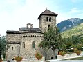
Saint Martin Basilica in Aime

Saint-Sigismond church

Jovet pen
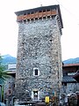
Montmayeur Tower
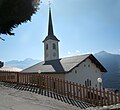
Saint Barthélemy Church in Granier


.jpg)


Personalities
- Valérie Ducognon (* 1972), ski mountaineer
- Delphine Oggeri (* 1973), ski mountaineer
Web links
Individual evidence
- ↑ Population figures retrospectively from January 1, 2016