Sainte-Hélène-sur-Isere
| Sainte-Hélène-sur-Isere | ||
|---|---|---|

|
|
|
| region | Auvergne-Rhône-Alpes | |
| Department | Savoie | |
| Arrondissement | Albertville | |
| Canton | Albertville-2 | |
| Community association | Arlysere | |
| Coordinates | 45 ° 37 ′ N , 6 ° 19 ′ E | |
| height | 298-2,294 m | |
| surface | 14.43 km 2 | |
| Residents | 1,183 (January 1, 2017) | |
| Population density | 82 inhabitants / km 2 | |
| Post Code | 73460 | |
| INSEE code | 73241 | |
| Website | http://www.ste-helene-sur-isere.fr/ | |
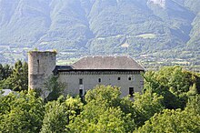
 View of Sainte-Hélène-sur-Isere |
||
Sainte-Hélène-sur-Isère is a French commune with 1,183 inhabitants (as of January 1 2017) in the department of Savoie in the region of Auvergne Rhône-Alpes . Sainte-Hélène-sur-Isère belongs to the canton of Albertville-2 (until 2015: canton of Grésy-sur-Isère ) in the Albertville arrondissement and is a member of the Communauté de communes de la Haute Combe de Savoie .
geography
Sainte-Hélène-sur-Isère is located about 31 kilometers east-northeast of Chambéry and about nine kilometers southwest of Albertville an der Isère . Sainte-Hélène-sur-Isère is surrounded by the neighboring communities of Saint-Vital and Frontenex in the north, Notre-Dame-des-Millières in the east and northeast, Saint-Paul-sur-Isère in the east and southeast, Bonvillard in the south, Aiton in the Southwest and fitter in the west and northwest.
The A430 autoroute runs through the municipality .
Population development
| 1954 | 1962 | 1968 | 1975 | 1982 | 1990 | 1999 | 2006 | 2017 |
|---|---|---|---|---|---|---|---|---|
| 660 | 635 | 600 | 620 | 645 | 859 | 993 | 1082 | 1183 |
| Sources: Cassini and INSEE | ||||||||
Attractions
- Sainte-Hélène Castle, built as a fortified house in the 13th century, rebuilt in the 17th century
Personalities
- Boniface of Savoy (1206 / 07–1270), Archbishop of Canterbury

